

| Online: | |
| Visits: | |
| Stories: |

| Story Views | |
| Now: | |
| Last Hour: | |
| Last 24 Hours: | |
| Total: | |
Submerged Structures & Cities Suggest Advanced Ice Age Civilizations


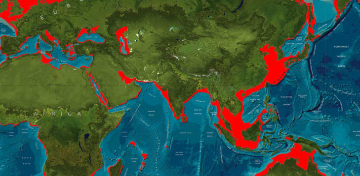
Submarine megalithic structures off the coasts of Malta, Egypt, Lebanon, India, China, and Japan in waters up to 70 meters deep were evidently submerged when the Ice Age ended and sea-level rose about 100 meters because of runoff from the melting of the Ice Age ice-packs (known as “isostatic Rebounding”)
Many of these megaliths were measuring devices, which indicates that their Ice Age constructors had astronomical map-making capabilities and sailed the seas, as demonstrated by a commonality of the architectural motifs of the megaliths worldwide, and as demonstrated by Turkish navigational maps which were sourced from ancient Phoenician maps and show coastlines of the Ice Age world with accuracies of latitude and longitude to not be matched until modern times.
Mainstream earth-chronologists insist that the Ice Age ended around 10000 B.C., at which point the sea-level rose to submerge these megaliths. However, the submerged megaliths are of designs and uses characteristic of around 2000 B.C. Are we therefore to believe that advanced civilizations actually began before 10000 B.C., and not around 3000 B.C. (as is commonly published)?
Mainstream archaeologists have said that the advanced civilizations of the Old and New Worlds appeared suddenly around 3000 B.C. without evidence of cultural and technological evolution to that pyramid-building level of mathematical and engineering sophistication, therefore, how can it be that the megaliths were submerged 12,000 years ago?
In the Rig Veda of ancient Hinduism, the text says that the N.W. Indian city of Dwarka was submerged by the encroaching ocean when the ancient patriarch Krishna died. Are we to believe that Krishna died around 10000 B.C, and therefore, that Hinduism is over 12,000 years old?
The megaliths of ancient Dwarka are in fact found submerged just offshore from modern Dwarka, and the huge stone walls built of megalithic blocks which had been interlocked with chiseled L-shaped dovetails are characteristic of the Indus Civilization that popularly is advertised to have had flourished near 2000 B.C., not 10000 B.C.
The Gulfs of Cambay and Kutch, just south of Dwarka, also hold submerged megalithic Indus Civilization structures that were covered by the ocean at the melting of the Ice Age.
Computer generated maps of the world as it was during the Ice Age reveal that ancient Dwarka was about 100 km inland during the Ice Age, and also inland were the now submerged Indus Civilization megaliths on the floor of the Gulfs of Kutch and Cambay, and as were the megaliths of Tamil pyramidal construction off the coast of southern India at Cape Cormorin and Madurai.
Ancient Hindu legends reveal that two Sangums (schools) were submerged by encroaching seas, and local divers say that the submerged pyramids look like the current Sangum pyramid at Madurai.
According to the computer generated Ice Age maps, about 25 million square miles of land were submerged by the rising sea-level because of the melting of the Ice Age ice-pack, and much of that land is now the floor of the shallow seas of southern Asia.
Are we to believe that these astronomically significant megaliths were built some 12,000 years ago at a time when mainstream earth-chronologists insist that the Ice Age ended and sea level as a result rose about 100 meters to engulf these megaliths which are evidently and contradictorily of 2000 B.C. vintage?
Are we to believe that the Hindu and Tamil recounts of history have been going on for 12,000 years, and that humanity developed no further and built no more for 7,000 years (from 10000 B.C. to 3000 B.C.) until advanced cultures reemerged in Egypt and Sumeria (Babylon)?
Such a torturous manipulation of the evidences from the archaeology and the ancient legends is unnecessary with the realization that the Ice Age did in fact end much later than is popularly advertised. Egypt and Sumeria were building their megaliths when the Indus, Tamil, and Jomon people were building theirs during the Ice Age.
The Ice Age ice-packs did melt rapidly and globally at the close of the Ice Age as evidenced by the legends about the ocean having risen to engulf historical cities, and by the contemporaneously deposited rock-debris fields from melted icebergs on the ocean-floors of the world which reveal that flotillas of icebergs concurrently broke-away from various continents at the close of the Ice Age and then melted to deposit together rocks from various parts of the world.
And the Ice Age ended within decades because the greater evaporation off the oceans required for the dense cloud-cover for the snow-blitz in the extreme latitudes and for the much greater rainfall in the middle latitudes was depleted as the oceans had finally cooled to today’s temperatures.
The Ice Age can only be explained by warmer oceans which induced greater evaporation to form the dense cloud-cover for the prolific snowfalls and rainfalls of the Ice Age, and this is confirmed by the increasing O18 isotope concentrations with depth in the polar ice-packs that reveal the fact that the oceans were cooling to today’s levels while the Ice Age ice-packs were accumulating.
Scientists have calculated that the oceans were about 10 degrees centigrade warmer at the beginning of the Ice Age, and that it took about 800 years for the ocean-water to cool to today’s temperatures when the Ice Age ended.
At the close of the Ice Age, as the two-mile-deep Ice Age ice-packs melted and ran-off into the oceans, isostatic rebound of the earth’s crust occurred beneath the then diminishing snow and ice overburden, and therefore, lands closer to the Ice Age ice-pack rose as the sea-level rose, so less land was claimed by the sea in the Mediterranean and the North Seas than was claimed by the seas around southern Asia.

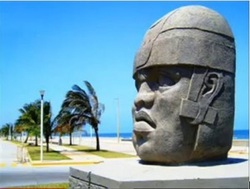
The ancient Olmecs of Central America had a legend that they came from across the eastern sea, and the onshore megalithic statues of the Olmecs depict their African facial features, and their language closely resembles that of the Mande of Africa who speak a Lybyco-Berber tongue.
The Toltecs and Mayans who sprang from the Olmecs built pyramids with astronomical orientations reflective of these peoples’ deep knowledge about the precession of the stars, so it seems that they also were astro-navigators who sailed the seas around 2000 B.C.
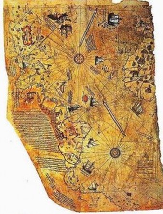
This map even accurately charted the rivers and bays of Antarctica before they were covered by the ice and snow of the Ice Age, and Admiral Piri Reis noted on this map that the source maps for his map were saved from the ancient Library of Alexandria by the Franks and were brought to Constantinople when that great Library of ancient Egypt was destroyed.
These ancient source maps known as portolani were credited to the “Tyranean Sea Fish” who were master-navigators from Phoenicia (Sidon), and who had linguistic affinity to the Lybyco-Berber-speaking Olmecs of Central America.
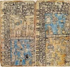 Popol Vuh
The obviously heavy volcanic ash content of this rain and the dense cloud-cover from which this rain came that blocked the sun to cause “constant twilight” shows that the Mayan ancestors arrived during the Ice Age.


And artistic seals discovered from the Indus Civilization portray parrots, monkeys, and elephants which suggests that the currently arid N.W. Indian and Pakistani region was then tropical because of the much heavier rains in the middle latitudes during the Ice Age.
 An artist’s interpretation of North Africa’s “SAHEL” inland sea during the Ice Age.
Lithic art in the Sahel portrays crocodiles, elephants, and deer which further corroborates human civilization during the Ice Age in the now arid Sahara desert of North Africa. There also is evidence of a port city at the base of the Ahaggar mountains of southern Algeria which was obviously thriving during the Ice Age.
Global warming could not have caused the higher evaporation rates from the ocean to cause the dense cloud-cover for the Ice Age, because with this type of ocean warming increased clouds would have shielded the earth from heat, and thus would have caused the atmosphere to cool back down, that is a buffer system within the hydrologic cycle.
Therefore, the heating of the oceans to cause the Ice Age must have come from below, from beneath the earth’s crust, that was the “Fountains of the Deep” of Noah’s Flood.
Hundreds of extant and ancient tribes speak of this global flood in their legends, and geology confirms that the vast sedimentary layers on the continents with billions of creatures therewith entombed were obviously deposited in a global flood that covered the continents.
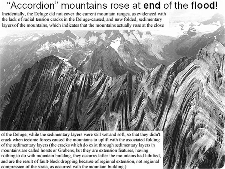
The lack of tension cracks in the now folded sedimentary layers of the mountains shows that the mountains rose after the sedimentary layers were deposited and while those layers were still moist and malleable, therefore, for these and many other reasons, the Genesis account should be acknowledged to be a semi-accurate account of ancient history.
Source of Article: http://www.apparentlyapparel.com/2/post/2014/04/submerged-structures-cities-prove-ice-age-ended-1500-bc.html


Civilization has risen and fallen many times; the earth experiences regular and predictable pole shifts periodically. Our ancient ancestors understood and have warned us with clues in monuments, myths, and religious texts. The Bible is full of such warnings and can be used to predict the next such event.
http://endtimesand2019.webs.com/
http://biblepoleshifts.webs.com/