

| Online: | |
| Visits: | |
| Stories: |

Flight MH17 Newest Information Was Fake. Did You Really Think They Would Tell You The Truth? I Have Obtained The Real Photo That Everyone Should See!! (Photo)

Flight MH17 Newest Information Was Fake. Did You Really Think They Would Tell You The Truth? I Have Obtained The REAL Photo That Everyone Should See!! (Photo)

FAKE!!!

FAKE!!!

FAKE!!!

FAKE!!!
From JayWill’s alternative surveillance resource network, you are about to view a true story, recorded recently, documenting facts pertaining to Flight MH17. This story is both dedicated to the faithful and presented to the falsehearted to encourage their research of truth and current events in the world in which we live today.
From the city of Gainesville Florida, Live in the heart of gator country, near the Gulf of Mexico, 50 miles west of the Atlantic Ocean, Good evening, Good morning, wherever you may be, across the USA or around the globe, Today is Monday 11/17/2014 and the time is 12:07pm, I’m JayWill and Welcome! Lots going on so let us begin. There has been lately a mass of information going out about a new Interesting satellite images supposedly confirming Flight MH17 shoot down image is consistent with flight path and debris field located in Ukraine. And given the status of the way things have been going latey you would think, Okay, now we have closure. But don’t count your chickens before they hatch. First of all, you have to ask your self the question, Why did they release these images now and who released them? According to Twitter and it’s from Russia Post. Really? Imagine that! A Russian Post! The same people we are suspecting who shot down the plane in the first place? I’m leaning toward what youtube poster DAHBOO77 said in his upload. DAHBOO77 states “ The caption translated reads: За мгновения до крушения «Боинга» под Донецком — уникальный кадр в аналитической программе «Однако» which translates to:
Moments before the crash “Boeing” near Donetsk – a unique frame in the analytical program “However”
It’s dated 14 Ноябрь, 2014 (November 14 2014)
I obviously cannot confirm it. But as you all know, the puppet regime in Ukraine has been pushing the “the Russians are invading” story all over again, they are deliberately shelling the crash site to destroy evidence and the war-mongering Ausies and Brits are accusing Moscow of shooting down Flight MH17 repeatedly in public.
If the Russians had this footage and were trying to play nice with the US and NATO countries before leaking it, now would be the time they get pissed off and let the rest of the world know they had nothing to do with shooting down that plane.
Yesterday, Russia released radar data that proved a Ukrainian military jet was in the area of Flight MH17 when it was downed. I wonder if someone leaked this to either bolster that evidence, or, if this is a bit of cognitive infiltration of disinformation, discredit it.
So there you have it! Disinformation! Trying to throw us off or should I say giving the dog a bone. So like I said in the heading, I have obtained the REAL photo and obviously I want you to see it because they don’t want this to get out and I don’t know how long it will last before it is removed. Questions will arise and lies will be told but all in all it’s up to you to judge. All I can really say is you have been lied to. What you choose to do with this information is up to you. Please Share It and let’s see what becomes of this. I am providing you with some vids and links that you should not believe because they contain false information. Enjoy!!! Be AWARE and be PREPARED, FEAR is not an option. Be safe everyone…
http://www.1tv.ru/news/leontiev/271824
Here are some vids that are not buying the lie. From the News and You youtube channel.
MH17 Latest News – Russian Tv Releases Fake MH17 Satellite Image
RUSSIAN TV RELEASES FAKE MH17 IMAGE
Russian state television has produced a “satellite image” that allegedly showed Flight MH17 being shot down by a fighter jet Friday, in what appeared to be a crude fake deliberately released on the eve of the G20 economic summit.
The state-controlled Channel One said the mysterious source who provided the images concluded they showed “how a Mig-29 fighter plane destroys the Boeing passenger plane”.
The channel also claimed the images came from either British or US satellites.
However, web experts claimed the picture was a forgery pointing out what they said were a mass of discrepancies.
Among them, the Malaysia Airlines’ logo was on the wrong side the clouds in the picture were identical to those in a Google Earth image from 2012, and the image was not consistent with the flight path of the jet.
From OPRACLEAKsALCAER youtube channel
The photos released in Russia of a fighter jet shooting down Malaysian airlines flight, MH17, have been labelled ‘fakes’ by an investigative journalism site which claims there are several inconsistencies
Were these MH17 ‘satellite images’ PHOTOSHOPPED? Report slams new surveillance photos released by Russian state broadcaster as a ‘shoddy fake’
Okay. So what everyone has been waiting for, This Is The REAL Photograph That Was Released!!!
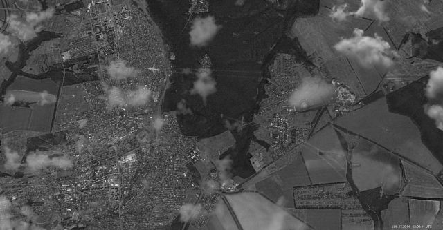
Notice the date and time mark at the bottom!!!


I ve looked at these images quite a lot, where is the cloud you say is is the original, that is also on Google Earth. I dont see that the images match up.
Look at the next to last photo. Supply me with an email address and I can send you the expanded version.