

| Online: | |
| Visits: | |
| Stories: |

500 Year Old Map Was Discovered That Shatters The “Official” History Of The Planet

by Arjun Walia
Collective Evolution
Human history is quite an enigma. We know so little, and much of what we think we know seems to be highly questionable in the wake of new evidence, as well as pre-existing information that challenges our current understanding of the world.
Our world is no stranger to unexplained mystery, and there are numerous examples of verified phenomenon, ancient monuments, books, teachings, understandings and more that lack any explanation and counter what we’ve already been taught. We are like a race with amnesia, able to put together small bits and pieces of our history yet unable to provide any sort of verified explanation. There are still many missing pieces to the puzzle.
One great example is the Piri Reis map, a genuine document that was re-made (copied from older documents) at Constantinople in AD 1513, and discovered in 1929. It focuses on the western coast of Africa, the eastern coast of South America, and the northern coast of Antarctica. It was drawn by the military intelligence of Admiral Piri Reis of the Ottoman era. He is a well-known historical figure whose identity is well established. The Admiral made a copy of it, and the original was drawn based on documents that date back to at least the fourth century BC, and on information obtained by multiple explorers.
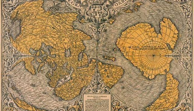
Why The Map Is So Compelling
Right off the bat, one of the most compelling facts about the map is that it includes a continent that our history books tell us was not discovered until 1818.
Read more »
Every Day is Earth Day
Source: http://www.riseearth.com/2015/02/500-year-old-map-was-discovered-that.html


They have hidden all the documents pertaining to real history, and created their own. Not really sure how the past generations were stupid enough to forget history, and let this happen. Must have been a great calamity to restart civilization, and mass knowledge was lost forever, if I had to guess.
Probably the same way we are doing it today. Make each generation just a little dumber than the previous and within several generations people forget how things were before except for those who are in control.
If the great library of Alexandria had not been burned and pillaged, there would be thousands of “prehistoric” documents giving the real truth today.
Ancient maps like the Piri Reis map definitely reveal that an ancient civilization mapped the whole world. Sub-glacial details in Antarctica suggest that it was mapped before the ice sheet covered western Antarctica – before the last pole shift.
But the map image in the article above is the Oronteus Finnaeus map of 1532, not the Piri Reis map of 1513.
When O.F. studied the ancient source map for the Antarctic portion he was unable to translate the lost language, and he misunderstood the the 80th degree of latitude (smaller) for the Antarctic Circle (larger) on the ancient map for which is why O.F. drew Antarctica much larger than it should be. For more info on such topics read Charles Hapgood’s Maps of the Ancient Sea Kings and my own End Times and 2019.
This information has been around for decades and is being heralded as a new revelation?
Also, “Piri” means “Admiral,’ so to refer to “Admiral Piri” Reis is a redundancy, an error that is repeated ad nauseam.
I feel “ad nauseam” after eating mexican food.
That’s because chickens are cannibals. Just sayin’…..
If people were truly interested in the answers to the truth about human origins and the REAL history of this planet and solar system, we must first understand that logic and reason is the only path to that end. Logic and reason dictate that impossibilities must be thrown out, this means religions and all the ambiguities they contain must be removed from the equation as these were the first attempts at altering the true history of our origins to serve those who held the answers but wanted to keep the knowledge for themselves in order to hold themselves above all other human beings as the controlling body for which the rest of humanity was to serve as slaves and concubines.
With all the scientists and scholars of the past, the basis for almost all research was the corrupted version of our history, and being as all starting points were based on lies, there was no way for any of them to truly succeed in finding real answers rather than just create more questions.
The most obvious of these examples was Darwin and his preposterous claims that modern humans were a result of evolution from Apes, yet to this day this theory was responsible for creating yet another unanswered question regarding what is described as a “missing link” between the early stages of Neanderthal and the modern slimmed down version that is considered early modern humans who somehow made a miraculous jump in physical appearance and intelligence that does not fit the evolution model.
Religions speak of “divine intervention” that for some reason never fully explained through logic and reason, why this “divine intervention” suddenly stopped and has not been realized by ANY culture for the last 2,000 years. Now when considering the mountains of physical evidence for advanced cultures all over the face of the planet, in order to answer the questions regarding who, what, why, when and how these physical formations and structures came to exist, we must again remove all impossibilities and through the same logical and reasonable deductions, learn to accept that what evidence remains must , however strange, be truth.
There are claims that there have been a total of seven heralds of truth that have come and gone throughout the past 13,000 years. These men of renown were made witness to past, and future events and occurrences in order to tell their stories to the population of Earth and help them understand the answers to the questions regarding the historical events that were obfuscated by the self proclaimed powerful and knowing ones who were responsible for the alterations in order to set themselves up as all powerful to reign over the rest of the planets population.
The names and birth dates of these men are, Enoch, born 2/3/9308 BCE, Elijah, born 2/5/891 BCE, Isaiah, born 2/7/772 BCE, Jeremiah, born 2/9/662 BCE, Jmmanuel, born 2/3/002 CE, Mohammed, born 2/19/571 CE, and Eduard, born 2/3/1937 CE. The information each of these men passed on was very similar, accept for the lives of the previous and the stories of their travels, the message was exactly the same, however after the passing of each of them, a new and different version of religion came about as their stories and lessons they taught were again, altered to serve the purpose of those who still demanded power and control over the masses.
For me to tell the whole story as I have come to accept it, would be far to lengthy for this post to be accepted, but the bottom line is this, the last in the line of seven true heralds of the truth is still among us trying to get the population to wake up and learn the truth in order to avoid unnecessary effects of false understandings and lies that have been forced upon us by these still to this day, power and control seeking individuals who still attempt to alter the truth for their personal gain in order to profit from the hard work of most of the population of this planet.
The evidence to support the story that this final herald of truth has been making available for us can be easily corroborated providing we truly want to know the answers to the questions that have plagued the truly interested for thousands of years. It only requires the willingness to see the logic and reason it entails and use logic and reason to understand the purpose to why the truth has been hidden in the first place.
For any culture to survive in peace, love, and harmony, and to evolve the way the natural laws dictate, the truth is the most necessary element, and the lack of truth is the cause to the effects that the world has been thrust into such prolonged misery for. If each and every individual could put their overly inflated ego in check for long enough to truly research the information Eduard Albert Meier, the last herald of truth this planet will ever see again, has made available to us, we just might be able to save the future of mankind on this planet and in this solar system, long enough to find a way off this spec of cosmic dust and take our rightful place in the universe as ambassadors of truth, knowledge, and wisdom, before our dying star causes our inevitable departure otherwise.
Jack
says, Billy?
Timothy, really?
Everyone, always, is
invited and welcome to visit
the following site, not to far away,
http://thetreasureofzion.com Yes, stop by.
7
Thank you for sharing your thoughts on something or other.
Next…!!
Tell me something, how do you get that ego of yours through any doorways?
Rather than prove what a douchebag you are, why not make it a little less obvious, I mean really that reply was such a window into your true character, you leave nothing to the imagination what so ever.
The Polynesian Maori people of New Zealand navigated across the Pacific “unaided”. Captain Cook’s discoveries were due to a Tahitian navigator who assisted him. The Maori legends of the origins of Aotearoa/New Zealand describe the topography in such a way that it could only have been viewed from above – whether in an out of body experience – or whatever.
Seriously people! Are you that desperate to find proof of your alternate universes? There is nothing mysterious about this map at all. The map is NOT centered on Cairo as the article seems to indicate. It is centered on the north and south poles. Because, as the article indicates, no one had discovered Antarctica yet, the cartographers mistakenly believed Australia was at the south pole. It was as far south as anyone had dared venture. So, they have placed Australia at the south pole.
The may be suggesting that the little strip of land at the bottom left of the left map is the north shore of Antarctica and that it reveals rivers not visible today. How stupid! That strip of land is clearly the east coast of South America. If you look at map on the right, you see that the southern hemisphere shows the Cape of Good Hope (Africa reaching toward Australia) and Cape Horn (South America) reaching toward Australia. In fact, these both reach toward Antarctica, but the cartographers did not know Antarctica existed because NO HUMANS HAD EVER SEEN IT. They had seen Australia way down south, and they had sailed around Africa and South America. They clearly believed Australia was the southern-most continent as it is in the center of their map of the southern hemisphere.
Now look back at the map on the left. That lower strip of land is nothing more than as much as they new at that time about South America. See that the strip continues along toward a series of islands. These are the Caribbean Islands. At that point the strip of land curves back toward the edge, which is where South America curves back toward the Gulf of Mexico (the Venizuelan coast). You can see a bump that comes from the edge toward the islands. That is Florida, with its keys continuing off of the bump. You can see the Virgin Islands to the East of Florida. Continue up and around further, and you see a very distorted understanding of the Newfoundland area of North America, near Greenland. You can see how it nearly touches Greenland, which is near Iceland, which is near England.
Remember that the Caribbean Islands were the first thing the Europeans discovered in exploring westward. (Well, except that the Scandinavians may have discovered North American, but no one knew it.) Spain had already begun to explore the coasts of the Americans in the early 1500s when the map was made, but they still mistakenly thought the east coast of North America was really the far east coast of Asia. That’s why you don’t even see a North American continent on this map. At this point, they believed they had traveled west all the way around the world and reached eastern Asia (Remember Columbus thought the Caribbean Islands were the “Indies,” which later had to be called the “West Indies” to distinguish them from the Islands Columbus thought he’d landed on.
Cartography was still in its infancy, and so everything newly discovered is fairly distorted. The protrusion of North America toward Greenland is hugely exaggerated. Part of that is just the difficulty of mapping a round world on a flat map, which causes major distortion even today. Nevertheless, you can clearly see all along the far western edge of that left-hand map the little bit that was known about the east coast of the newly discovered Americas. No one envisioned that they were vast continents yet. They would within a few more years, but that was, at most, a vague idea back in the very early 1500s. Remember that the explorers’ original intention was to travel west around the world until they met the east coast of Asia or of India to develop trade routes to the far east. They thought that was what they discovered, so that is what they mapped.
They had no idea Antarctica existed, and only a child’s notion of the extensive mysterious coastline they had discovered in the Americas and no concept at all of the vast Pacific Ocean that dwarfs the Atlantic. Notice that the Pacific Ocean doesn’t even exist on this map nor the ocean around Antarctica and certainly not Antarctica, itself. This is, in fact, EXACTLY what you would expect a map of the “new world” to look like because they had only discovered the tip of the iceberg at this point.
–Knave Dave
There are strange thing out there .
1 . As this : A ancient computer found http://upload.wikimedia.org/wikipedia/commons/6/66/NAMA_Machine_d'Anticythère_1.jpg
Ancient Computer Found In Roman Shipwreck
September 16, 2014 | by Justine Alford
http://www.iflscience.com/technology/new-shipwreck-expedition-may-unlock-secrets-worlds-oldest-computer
“Nicknamed the “Big Fat Greek Expedition,” archeologists this week have embarked on a new mission to explore an ancient wreckage where one of the most complicated scientific antiques in existence was discovered over 100 years ago in the Aegean Sea.”
old old old news dude your way behind… and your stupid.
Ok so i lied
