

| Online: | |
| Visits: | |
| Stories: |

5 YEARS LATER: BP / Gulf Oil Spill – 68,000 Square Miles of Direct Impact

2010 BP OIL SPILL – GULF OF MEXICO – WHAT HAPPENED and WHAT IS IT LIKE TODAY?
Tuesday, July 27, 2010
So here’s a map showing the cumulative oil slick footprint for the BP / Deepwater Horizon oil spill, created by overlaying all of the oil slicks and sheen mapped by SkyTruth on satellite images taken between April 25 and July 16, 2010, blogged here, and published in our gallery.
Cumulatively, the surface oil slicks and sheen observed on these satellite images directly impacted 68,000 square miles of ocean - as big as the state of Oklahoma:
 Map showing cumulative oil slick footprint from BP / Deepwater Horizon oil spill, based on satellite images taken between April 25 and July 16, 2010
Crude oil is also a complex mixture of many different types of hydrocarbon, each with its own set of properties, including toxicity and metabolic pathway.
“The effect on sea life of the large amounts of oil that dissolved below the surface is still a mystery. Two preliminary government reports on that issue have found concentrations of toxic compounds in the deep sea to be low, but the reports left many questions, especially regarding an apparent decline in oxygen levels in the water.
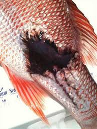
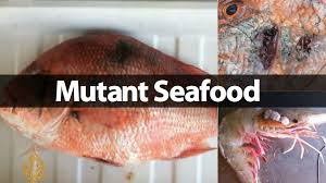
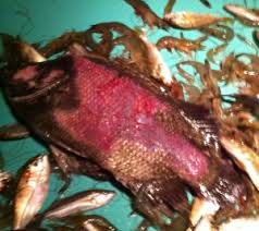
And understanding the effects of the spill on the shorelines that were hit, including Louisiana’s coastal marshes, is expected to occupy scientists for years. Fishermen along the coast are deeply skeptical of any declarations of success, expressing concern about the long-term effects of the chemical dispersants used to combat the spill and of the submerged oil, particularly on shrimp and crab larvae that are the foundation of future fishing seasons.”


NESARA- Restore America – Galactic News
Source: http://nesaranews.blogspot.com/2015/08/5-years-later-bp-gulf-oil-spill-68000.html
