


| Story Views | |
| Now: | |
| Last Hour: | |
| Last 24 Hours: | |
| Total: | |
Louisiana Flood: Godzilla El Nino Targets New Orleans

By Deborah Dupré
New Orleans is bracing for yet another major disaster as the long-awaited Godzilla El Nino aims at millions more caught in a south Louisiana nightmare in which the death toll is mounting. Over 20 inches of deadly rain have fallen in the state’s northern region, now heading down south along with an expected added 14 more inches of rain – two feet in total, damaging winds, possible tornadoes, flash flooding and levees near toppling. Add hundreds of oil and gas refineries and nuclear plants at high risk. Thousands have fled.
After Hurricane Katrina, BP’s oil catastrophe and Hurricane Isaac, the oil industry and crisis capitalists might gain more coveted area as more residents lose their homes to the same industry that helped trigger this storm.
Louisiana’s northern area reels and weeps from unprecedented quickly rising waters that took five lives and many homes where 1000s have been evacuated. Today, south Louisiana began tasting El Nino’s wrath. There, over the next couple of days, over a foot of rain is predicted.
Disaster is imminent. The flood threat has only just begun. It will remain even after rain ends, as water seeps into the ground and works its way into progressively larger rivers, AccuWeather reported.
See: Louisiana Evacuations. Military Deployed
State officials reported that a 6-year-old girl was among those killed during the first two days of severe weather in the north of the state, that left roads covered in water and sent people fleeing in boats from their flooded homes.
South Louisiana Braces for the Worst
The El Nino system is just entering the south of the state.
“It’s entirely possible, if not likely, that some spots could get up to 8 inches by Friday morning,” said Bob Wagner, meteorologist at the National Weather Service in Slidell, according to The Advocate.
Rain will continue in Baton Rouge into Saturday, but heaviest rain is moving east straight toward New Orleans, where it is to arrive late today and continue pounding it into Saturday morning, according to meteorologists.
Thursday monring, the Times Picayune reported a forecast discussion message saying, “Significant flooding issues could arise with this event, given the high rainfall totals expected.”
Watch Louisiana Apocalyptic Flooding
The Weather Prediction Center has warned residents to expect 1 to 2 inches of rainfall per hour.
The system prompted Gov. Edward Bell to declare a State of Emergency. Over 200 National Guardsmen equipped with dozens of boats, trucks that can travel though water 20 to 30 inches deep, and equipment for rescues are busy or on call, with more on the way.
Thursday, rescuers established one staging area along Highway 71 in Bossier Parish. Using boats and trucks high enough to drive through the water, they went through the community evacuating people and their pets from their homes.
For months meteorologists have warned that a super-El Nino would be devastating.
“There’s no longer a possibility that El Niño wimps out at this point,” climatologist for NASA’s Jet Propulsion Laboratory in La Cañada Flintridge Bill Patzers said in mid-October. “It’s too big to fail.”
Dramatic worst case scenarios forecast in August have been confirmed. Super El Niño 2015-16 has already brought powerhouse storms faster and hitting harder than its predecessors. Pacific Ocean temperatures having risen three to six degrees warmer than average due to global warming, have spurred a Super El Niño Watch due to anticipated historic rain-related devastation: floods and landslides. New Orleans’ time has come, again.
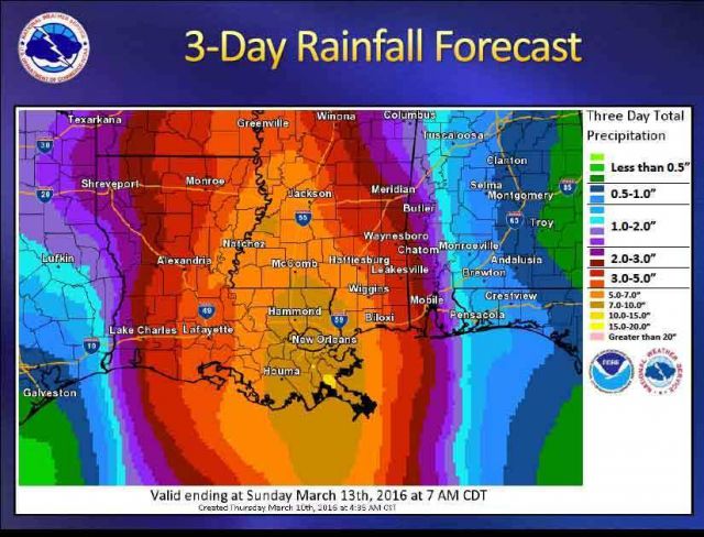
New Orleans Told Prepare for up to 14 Inches Rain

Now, as the system impacts the southern part of the state, meteorologists predict three-day storm totals through Saturday night “could vary from 7 to 10 inches for the Baton Rouge area and Mississippi Gulf Coast to a bullseye of 10 to 14 inches for metro New Orleans and the north shore by the time the event is over.”
High winds and a tornado or two were said to be possible as the strongest of thunderstorms pass over the area.
While much of the north of the sate is already under mandatory evacuations, southern residents have been warned to prepare by having Go-Bags ready and a plan for escaping. That is no consolation for the less fortunate without transportation, not that roads will be open anyway. Already road closures are occurring, bridges are flooded and some roads have buckled making them impassable.
Prompting emotional flashbacks of Hurricane Katrina, New Orleans and other southern Louisiana residents have been told to prepare.
“People need to think about where they’re driving,” he said. “Even if it looks like the water’s calm, people shouldn’t be driving through it. Turn around; don’t drown.”
Shawn Powell, his wife, their two children, dog and guinea pig left their home in the Pecan Grove subdivision early Thursday on the back of a National Guard truck.
Powell said he had watched a Bossier Parish sheriff’s deputy remove his neighbors across the street from their home in a boat Wednesday afternoon.
“At 2 a.m.. (Thursday) as the water approached my house, I knew it was time to go,” Powell said.
“As we were traveling out of the neighborhood, I didn’t realize how bad it was,” Powell said. “The water was up to roofs of homes, and you could see the tops of cars.”
Powell, his family and the pets were taken to the Red Cross shelter at the civic center.
“We brought with us a change of clothes and that’s all,” Powell said.


it isn’t the el nino causinng it… 2011 was one of the biggest flooding disasters. and that wasn’t a el nino year