


| Story Views | |
| Now: | |
| Last Hour: | |
| Last 24 Hours: | |
| Total: | |
Hidden for All of Human History, a 460 Mile Long Mega Canyon has been Discovered in Greenland
Friday, August 30, 2013 7:05
% of readers think this story is Fact. Add your two cents.

Greenland’s Mega Canyon
Hidden for all of human history, a 460 mile long canyon has been discovered below Greenland’s ice sheet.
Using radar data from NASA’s Operation IceBridge and other airborne campaigns, scientists led by a team from the University of Bristol found the canyon runs from near the center of the island northward to the fjord of the Petermann Glacier.
Watch the video:Hidden for All of Human History, a 460 Mile Long Mega Canyon has been Discovered in Greenland
https://www.youtube.com/watch?v=Z1QsoBAUlac

Image: NASA
IceBridge, a six-year NASA mission, is the largest airborne survey of Earth’s polar ice ever flown. It will yield an unprecedented three-dimensional view of Arctic and Antarctic ice sheets, ice shelves and sea ice.
These flights will provide a yearly, multi-instrument look at the behavior of the rapidly changing features of the Greenland and Antarctic ice.
Data collected during IceBridge will help scientists bridge the gap in polar observations between NASA’s Ice, Cloud and Land Elevation Satellite (ICESat) — in orbit since 2003 — and ICESat-2, planned for late 2015.
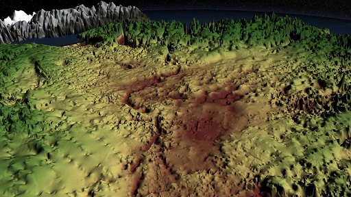
Image: NASA
ICESat stopped collecting science data in 2009, making IceBridge critical for ensuring a continuous series of observations. IceBridge will use airborne instruments to map Arctic and Antarctic areas once a year.
The first IceBridge flights were conducted in March/May 2009 over Greenland and in October/November 2009 over Antarctica. Other smaller airborne surveys around the world are also part of the IceBridge campaign.
For more information:


“…towards the fjords of the Petermann Glacier.”- Not THE J Petermann is it.