


| Story Views | |
| Now: | |
| Last Hour: | |
| Last 24 Hours: | |
| Total: | |
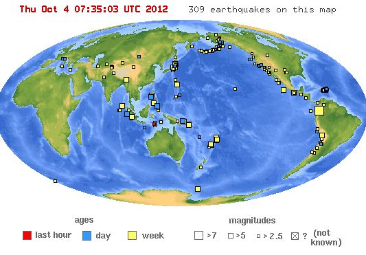
7187 Earthquakes In 30 Days

Today's earthquake fact: A powerful magnitude 7.9 earthquake struck Alaska on November 3, 2002, rupturing the Earth's surface for 209 miles along the Susitna Glacier, Denali, and Totschunda Faults. Striking a sparsely populated region, it caused thousands of landslides but little structural damage and no deaths. Although the Denali Fault shifted about 14 feet beneath the Trans-Alaska Oil Pipeline, the pipeline did not break, averting a major economic and environmental disaster. This was largely the result of stringent design specifications based on geologic studies done by the U.S. Geological Survey (USGS) and others 30 years earlier. Studies of the Denali Fault and the 2002 earthquake will provide information vital to reducing losses in future earthquakes in Alaska, California, and elsewhere.
| 7.3 | 9km WNW of San Agustin, Colombia | 2012-09-30 16:31:35 | 1.920°N | 76.355°W | 170.0 |
| 6.2 | 96km ENE of Miyako, Japan | 2012-10-01 22:21:45 | 39.853°N | 143.047°E | 9.7 |
| 6.0 | 112km SE of Gizo, Solomon Islands | 2012-09-27 23:53:49 | 8.825°S | 157.557°E | 10.0 |
| 5.7 | 166km WNW of Sikabaluan, Indonesia | 2012-10-03 13:32:34 | 0.451°S | 97.648°E | 10.0 |
| 5.5 | 12km SSE of Cuajinicuilapa, Mexico | 2012-09-29 07:11:13 | 16.355°N | 98.388°W | 10.2 |
| 5.4 | 296km NNE of Farallon de Pajaros, Northern Mariana Islands | 2012-09-30 15:35:53 | 22.992°N | 146.050°E | 35.0 |
| 5.4 | 102km ESE of Pondaguitan, Philippines | 2012-10-03 18:28:33 | 5.860°N | 126.955°E | 144.5 |
| 5.4 | 39km E of Tarata, Peru | 2012-09-29 17:48:57 | 17.480°S | 69.660°W | 126.0 |
| 5.3 | 281km NNW of Scott Island Bank, Antarctica | 2012-10-02 19:41:29 | 65.008°S | 177.926°E | 16.6 |
| 5.3 | 91km WSW of Neiafu, Tonga | 2012-10-02 03:33:30 | 18.820°S | 174.836°W | 96.7 |
| 5.3 | 212km SSW of Mohean, India | 2012-09-29 11:24:33 | 6.115°N | 92.810°E | 28.5 |
| 5.3 | 202km S of Taron, PNG | 2012-10-03 06:26:17 | 6.277°S | 152.746°E | 30.5 |
| 5.2 | 18km ESE of Iwaki, Japan | 2012-10-01 18:40:52 | 36.959°N | 141.059°E | 6.7 |
| 5.2 | 93km NW of Curup, Indonesia | 2012-10-02 17:37:24 | 2.876°S | 101.931°E | 116.6 |
| 5.2 | 115km SSE of Gizo, Solomon Islands | 2012-09-28 23:22:31 | 8.976°S | 157.426°E | 10.0 |
| 5.1 | 14km ENE of Rangapara, India | 2012-10-02 18:37:40 | 26.847°N | 92.788°E | 51.6 |
| 5.1 | 55km ENE of `Ohonua, Tonga | 2012-10-02 11:35:51 | 21.109°S | 174.474°W | 34.7 |
| 5.1 | 14km NNW of Dumingag, Philippines | 2012-10-02 06:25:31 | 8.293°N | 123.314°E | 41.1 |
| 5.1 | 107km E of Miyako, Japan | 2012-10-01 22:55:51 | 39.776°N | 143.189°E | 37.9 |
| 5.1 | 241km SW of Tomatlan, Mexico | 2012-10-01 17:32:31 | 18.713°N | 107.151°W | 21.3 |
| 5.0 | South of the Fiji Islands | 2012-10-01 17:24:42 | 24.588°S | 179.380°W | 461.8 |
| 5.0 | 111km ESE of Kimbe, Papua New Guinea | 2012-10-03 21:02:38 | 5.765°S | 151.126°E | 56.9 |
| 5.0 | 90km S of Pangai, Tonga | 2012-10-02 18:39:08 | 20.607°S | 174.229°W | 3.1 |
| 5.0 | South of the Fiji Islands | 2012-09-27 16:54:44 | 24.893°S | 179.256°W | 515.1 |
| 5.0 | 16km SW of Tayaman, Philippines | 2012-10-04 01:55:20 | 13.131°N | 120.457°E | 58.5 |
| 5.0 | 3km NE of Hukay, Philippines | 2012-09-29 14:12:04 | 13.869°N | 120.730°E | 186.1 |
