


| Story Views | |
| Now: | |
| Last Hour: | |
| Last 24 Hours: | |
| Total: | |
100,000 Fled To Higher Ground In Hawaii From Tsunami From 7.7 Earthquake Off Vancouver

Tsunami warnings prompted by a 7.7 earthquake off the Canadian coast on Friday caused more than 100,000 people to flee from Hawaiian shores to higher ground in the state late on Saturday evening, but the evacuation order was canceled after a series of smaller than expected waves crashed on the islands The tsunami was unusual in that it came from the east, an ocurrence that had not been observed for hundreds of years. Geologists say the 7.7 quake could be a precursor to a larger earthquake but there is no way of knowing. The Canadian quake was in the Cascadia earthquake zone.
A tsunami was generated that could have caused damage along coastlines of all islands in the state of Hawaii. Urgent action was urged yesterday to protect lives and property.
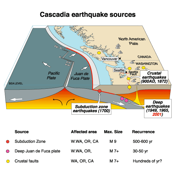
The 1700 Cascadia earthquake was a magnitude 8.7 to 9.2 megathrust earthquake that occurred in the Cascadia subduction zone on January 26, 1700. The earthquake involved the Juan de Fuca Plate underlying the Pacific Ocean, from mid-Vancouver Island in British Columbia, Canada, south along the Pacific Northwest coast as far as northern California, USA. The length of the fault rupture was about 1,000 kilometers (620 miles) with an average slip of 20 meters (22 yards).
The earthquake caused a tsunami that struck the coast of Japan and Hawaii and may also be linked to the Bonneville Slide.
A tsunami is a series of long ocean waves. Each individual wave crest can last 5 to 15 minutes or more and extensively flood coastal areas. The danger can continue for many hours after the initial wave as subsequent waves arrive. Tsunami wave heights cannot be predicted and the first wave may not be the largest.
The geological record reveals that "great earthquakes" (those with moment magnitude 8 or higher) occur in the Cascadia subduction zone about every 500 years on average, often accompanied by tsunamis. There is evidence of at least 13 events at intervals from about 300 to 900 years with an average of 570—590 years. Previous earthquakes are estimated to have occurred in 1310 AD, 810 AD, 400 AD, 170 BC and 600 BC.
Credit: Wikipedia
As seen in the 1700 quake, the 2004 Indian Ocean earthquake, and the 2011 Tōhoku earthquake, subduction zone earthquakes can cause large tsunamis, and many coastal areas in the region have prepared tsunami evacuation plans in anticipation of a possible future Cascadia earthquake. However, the major nearby cities, notably Seattle, Portland, Vancouver, Victoria, and Tacoma, which are located on inland waterways rather than on the coast, would be sheltered from the full brunt of a tsunami. These cities do have many vulnerable structures, especially bridges and unreinforced brick buildings; consequently, most of the damage to the cities would probably be from the earthquake itself. One expert asserts that buildings in Seattle are vastly inadequate even to withstand an earthquake of the size of the 1906 San Francisco earthquake, much less the much greater one that may well occur.[7]
Recent findings conclude that the Cascadia Subduction zone is more complex and volatile than previously believed. In 2010 geologists predicted a 37 percent chance of an M8.2+ event within 50 years, and a 10 to 15 percent chance that the entire Cascadia Subduction will rupture with an M9+ event within the same time frame. Geologists have also determined the Pacific Northwest is not prepared for such a colossal quake. The tsunami produced could reach heights of 80 to 100 feet (24 to 30 m).
Cascadia subduciton zone.

Some other subduction zones have such earthquakes every 100 to 200 years; the longer interval results from slower plate motions. The rate of convergence between the Juan de Fuca Plate and the North American Plate is 60 millimetres (2.4 in) per year.
Tsunami waves efficiently wrap around islands. All shores are at risk no matter which direction they face. The trough of a tsunami wave may temporarily expose the seafloor but the area will quickly flood again. Extremely strong and unusual nearshore currents can accompany a tsunami. Debris picked up and carried by a tsunami amplifies its destructive power. Simultaneous high tides or high surf can significantly increase the tsunami hazard. The estimated arrival time in hawaii of the first tsunami wave is 1028 pm hst sat 27 oct 2012

| Magnitude | 7.7 |
|---|---|
| Date-Time |
|
| Location | 52.769°N, 131.927°W |
| Depth | 17.5 km (10.9 miles) |
| Region | QUEEN CHARLOTTE ISLANDS REGION |
| Distances |
139 km (86 miles) S of Masset, Canada 202 km (125 miles) SSW of Prince Rupert, Canada 293 km (182 miles) SW of Terrace, Canada 556 km (345 miles) NW of Campbell River, Canada |
| Location Uncertainty | horizontal +/- 14 km (8.7 miles); depth +/- 4 km (2.5 miles) |
| Parameters |
NST=716, Nph=716, Dmin=267.2 km, Rmss=0.95 sec, Gp= 58°, M-type=regional moment magnitude (Mw), Version=A |
| Source |
|
| Event ID | usb000df7n |
