
| Visitors Now: | |
| Total Visits: | |
| Total Stories: |
Gulf Coast storm system about to deepen into East Coast Nor’Easter
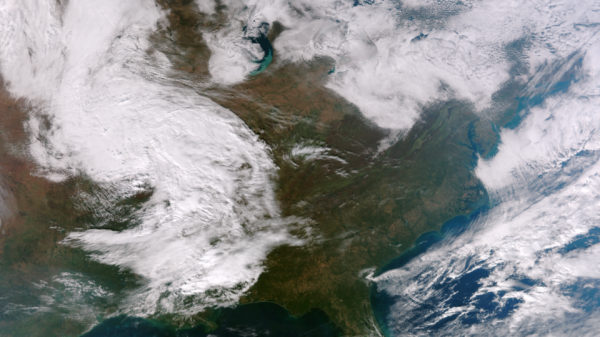
Storm along the central Gulf coast will move eastward to the eastern Florida coast and deepen into nor’easter storm which will form off the coast of South Carolina on Tuesday evening. The storm is forecasted to accelerate north-northeastward on Wednesday, with a central pressure expected near 984 mB . The system is expected to travel northward paralleling the east coast northward to off the Delmarva Peninsula by Wednesday morning. This will affect the areas that were hardest hit by Hurricane Sandy last week. It should intensify into a medium-strength nor’easter storm, pulling in cold Arctic air from Canada. As the storm strengthens, winds are expecting to reach 95 to 115 km/h ( around 60 to 70 mph).

This image was taken by the NASA/NOAA Suomi NPP satellite around 18:40 UTC on November 5, 2012. (Credit: NASA/NOAA)
High, battering waves, could cause severe erosion along the coastal areas pounded by Hurricane Sandy last week. Beach erosion caused by Sandy and washed up sand dunes could hardly stop the surge, especially along the New Jersey coastline. A storm surge of 2 – 4 feet would likely hit the New Jersey coast, and a storm surge of 3 – 5 feet would likely impact the western end of Long Island Sound.
At the present time, AccuWeather.com meteorologists are expecting a 2 to 4-foot water rise on top of the tide level from about Ocean City, Md., through Atlantic City, Belmar and Sandy Hook, N.J. The worst of coastal flooding is expected Wednesday afternoon and again late Wednesday night, as the hide tides appearing that day. There isn’t much protection in place to hold the water back so coastal residents are urged to take precaution against more rising water.

Forecast rainfall totals for the next five days (Credit: NOAA)
Saturated ground will receive additional rain amounts which will lead to flooding of low-lying and poor drainage areas, causing streams and creeks to rise over their banks.

GOES East satellite image of developing system (NASA/NNVL)
Nor’easter has the potential to bring more than a foot of snow to mountain areas of New England. Additional power outages and damage to trees will be likely due to the already soft saturated ground in place across the region. About 1.26 million people are still without power in the Northeast.

North Atlantic Infrared (GOES East)
Nor’easter: City-by-city impact forecasts (TWC)
NOAA National Weather Service Hydrometeorological Prediction Center
Featured image credit: Exponent
Related posts:
- Nor’eastern storm about to hit East Coast, bringing more fears of coastal flooding and beach erosion A nor’easter is predicted to potentially hit the East Coast...
- More than 1,5 million lose power during rare October storm A rare October snowstorm bore down on the heavily populated...
Gulf Coast storm system about to deepen into East Coast Nor’Easter
2012-11-06 07:42:01
Source:


