


| Story Views | |
| Now: | |
| Last Hour: | |
| Last 24 Hours: | |
| Total: | |
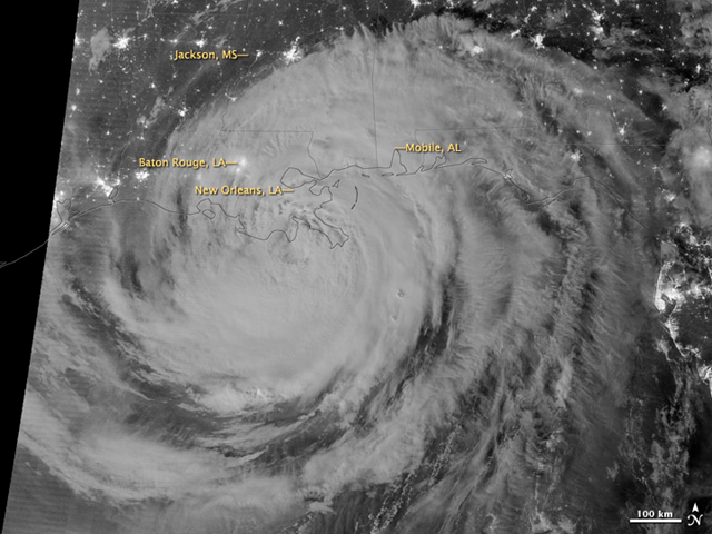
Image of the Day: Nighttime satellite view of Hurricane Isaac, 29 August 2012

Caption by Adam Voiland
30 August 2012Early on 29 August 2012, the Visible Infrared Imaging Radiometer Suite (VIIRS) on the Suomi-NPP satellite captured this nighttime view of Hurricane Isaac and the cities near the Gulf Coast of the United States. The image was acquired at 1:57 a.m. local time (6:57 Universal Time) by the VIIRS “day-night band,” which detects light in a range of wavelengths from green to near-infrared and uses light intensification to enable the detection of dim signals. In this case, the clouds of Isaac were lit by moonlight.
Isaac, a slow-moving storm, made landfall as a category 1 hurricane near the mouth of the Mississippi River in southwestern Louisiana at about 6:45 p.m. local time on August 28. It then moved westward and back out over water until making a second landfall near Port Fourchon at about 4:00 a.m. on August 29. A weakening Isaac churned slowly northwest throughout the day at speeds of just 6 miles (9 kilometers) per hour, slow enough that forecasters expected the storm to drop 7 to 14 inches (18 to 36 centimeters) of rain across much of Louisiana, southern Mississippi, and southwestern Alabama.
Read a more detailed description of the storm from the satellite perspective at NASA’s Hurricane Resource Page. Also, the National Hurricane Center provides the official U.S. storm forecasts and regular updates on conditions on its home page.
2012-08-30 10:55:13
Source: http://www.desdemonadespair.net/2012/08/image-of-day-nighttime-satellite-view_30.html
Source:
