


| Visitors Now: | |
| Total Visits: | |
| Total Stories: |

| Story Views | |
| Now: | |
| Last Hour: | |
| Last 24 Hours: | |
| Total: | |
Marcellus Shale Hydrofracking Surface Water Impacts

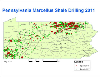
The activity is hot in PA thus far this year:
 With plans to head out for further field sampling in the final weekend of July, we will revisit the same sites again to measure the comprehensive water quality the Wysox and Meshoppen watersheds. We will use an approach where we are sampling throughout the watershed to establish norms for what to expect and better pinpoint any changes in vital signs, be it visual or quantitative (conductivity levels, turbidity readings). We aim to use our data in part to gain knowledge in order to accurately construct ‘load maps’ for watersheds in PA. A load map is intended to reflect the number of drill sites or permits per square mile in a watershed.
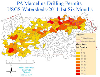
In western PA the watersheds of Little Connoquenessing, and Tenmile Creek show high levels. The permits used to make the map are from the past six months. Generally once a permit is obtained drilling starts with in 3 to 6 months, so a high density of new permits means locals can expect a frenzy of fracking in the near future. In northern PA the watersheds of Larry’s Creek, Wysox Creek and East Branch Wyalusing have high permits levels.
The load approach looks to be a valuable one, and according to research done by scientists of the National Academy and a University of Pennsylvania grad student, the impact of drilling seems to be tied to the density of drilling in a specific area (a watershed in our case). It appears that there is a ‘threshold point’ where it becomes environmentally degrading regardless to the care of the drilling companies.In the watersheds in which we visited, it seemed that individual drill pads looked fine, if not a scar on the land, but once we were in the air (courtesy of LightHawk) the sheer amount of activity was gut-wrenching.
Source:
