

| Online: | |
| Visits: | |
| Stories: |

| Story Views | |
| Now: | |
| Last Hour: | |
| Last 24 Hours: | |
| Total: | |
Mapping Inactive Metal Mines Across the US

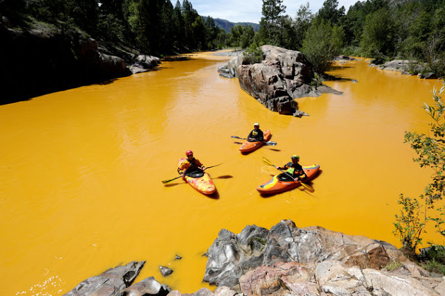
People kayak in the Animas River near Durango, Colo., in water colored from a mine waste spill.Jerry Mcbride/The Durango Herald, via Associated Press
Earlier this month yet another river famous for trout and whitewater was poisoned with toxic orange wastewater from a derelict mine. On August 5, the Animas River in southwestern Colorado was subjected to at least a 3,000,000 gallon discharge of acidic, metal-laden mine waste from the Gold King Mine when contractors for the U.S. Environmental Protection Agency (EPA) accidentally breached a mine pool while investigating a leak from the inactive mine.
While headlines across the western U.S. point fingers at mine operators, the EPA, state agencies, politicians, local residents, and even environmentalists (some lawmakers going so far as to publicly speculate about whether the EPA might have conspired to cause the spill on purpose), tens of thousands of these toxic sites lie scattered across the nation. With all the attention on the problem of abandoned and inactive mines we thought we would try to map some of these other mines that haven’t made headlines (yet).
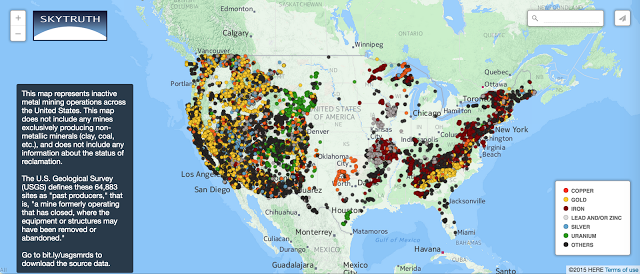
The most extensive nationwide dataset that we could find was the U.S. Geological Survey’s (USGS) Mineral Resources Data System (MRDS), which contains information about over 266,000 sites in the United States. However, “most extensive” is a relative term; according to the Bureau of Land Management, there may be as many as 500,000 abandoned mines in the United States. What the USGS data doesn’t tell us is anything about the status of reclamation and who is responsible for cleaning up the site and treating any discharge in perpetuity. Click the image to explore the interactive map.
So the very best that we could do to visualize inactive mines using this data was to select only the mines whose development status as of 2012 was listed as a “Past Producer“, that is, “[a] mine formerly operating that has closed, where the equipment or structures may have been removed or abandoned.” In order not to clutter the map with quarries and gravel pits, we also excluded sites that exclusively produced nonmetallic commodities. This leaves us with the 64,883 mines you see above, ranging from 200+ year old gold mines in Virginia to Cold War era uranium mines in the Four Corners.
 |
| Credit - Sandhillfarms1625 |
What we should all take away from this map (besides an appreciation for the immense number of holes we’ve dug in the ground), is the alarming lack of comprehensive data about the scope and scale of the abandoned mine problem. Even counting the quarries and gravel pits, the MRDS dataset only contains 118,399 records for past producers in the US, and the Office of Surface Mining’s enhanced Abandoned Mine Lands Inventory System(eAMLIS) database (not included in this map) only contains 53,794 records,mostly for coal. That leaves us nearly 328,000 mines short of BLM’s aforementioned estimate of half a million abandoned mine lands.
More than anything, this map shows how the public is largely in the dark about the inactive mine lands that litter the landscape. Furthermore, we have little information about which of these thousands of points on the map have been reclaimed, and which are toxic abscesses in the earth’s surface just waiting to poison another river with the orange stain of mine waste.
You can download and examine the raw data for yourself at bit.ly/usgs_mrds. Do you know of other federal datasets we should look at for information on inactive metal mines? Leave a link in the comments below.
Source: http://blog.skytruth.org/2015/08/inactive-metal-mines.html
