| Online: | |
| Visits: | |
| Stories: |

| Story Views | |
| Now: | |
| Last Hour: | |
| Last 24 Hours: | |
| Total: | |
Mushroom contamination map shows contaminated products mainly consumed in Kanto area
Mushroom contamination map shows contaminated products are mainly distributed and consumed in Kanto area.
The map is based on MHLW (Ministry of Health, Labour and Welfare) ‘s analysis on 330,000 mushroom samples in 2013.
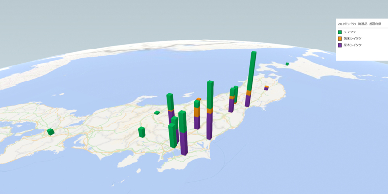
The online uncontaminated food distributer, “Whitefood” plotted the cases that MHLW detected Cesium-134/137 from a mushroom on Japanese map.
The map below shows the number of contaminated Shiitake mushroom in municipal governments. These mushrooms were not supposed to be distributed.
It shows the major part is consumed in Kanto area more than North Eastern Japan.
The map below shows the number of contaminated Shiitake mushroom in municipal governments. MHLW admits these mushrooms were distributed for sales.
http://www.whitefood.co.jp/news/foodmap/1457/
Iori Mochizuki I tried to install a Bitcoin button on the sidebar. Because I don’t have bitcoin, I can’t test it to see if it works. I would be very glad if you use it for a test.The post Mushroom contamination map shows contaminated products mainly consumed in Kanto area appeared first on Fukushima Diary.
Source: http://fukushima-diary.com/2014/09/mushroom-contamination-map-shows-contaminated-products-mainly-consumed-kanto-area/


