
| Online: | |
| Visits: | |
| Stories: |
Daily Weather Briefing for Thursday, March 30, 2017
NATIONAL OVERVIEW
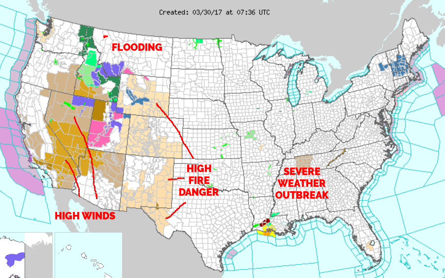
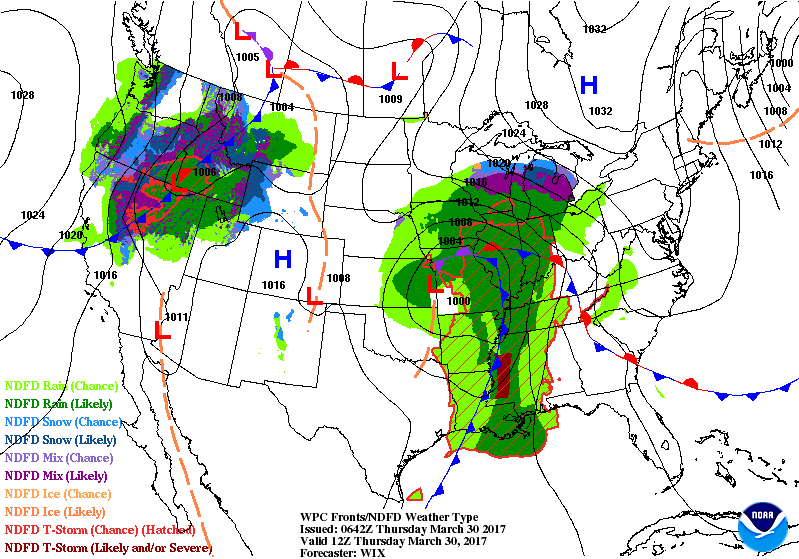
…Severe thunderstorm potential through Thursday over the Middle/Lower Mississippi and Tennessee Valleys…
…Heavy snow likely for the Northern/Central Rockies, Great Basin and Wasatchs…
…Heavy rain for portions of the Pacific Northwest and the Lower/Middle Mississippi Valley…
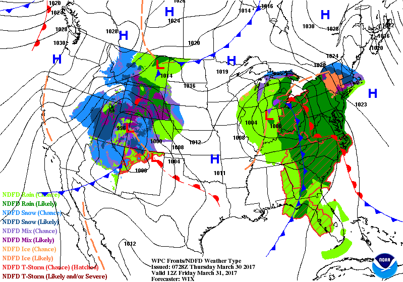
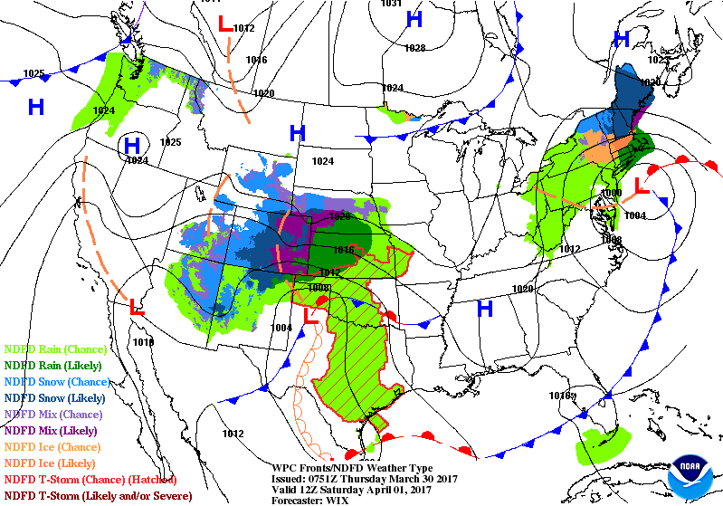
Widespread showers and thunderstorms are forecast for much of the central U.S as a robust low pressure system tracks across the Midwest and through the Tennessee/Ohio valley. The Storm Prediction Center has identified conditions favorable for continued support for severe thunderstorms development across the Middle/Lower Mississippi valley and western portions of the Tennessee valley today and Thursday. Additionally, some of these storms may produce heavy rainfall; which may increase the threat for flash flooding. Refer to SPC’s Convective Outlooks and WPC’s Excessive Rainfall Outlooks for specific details. This system is expected to reach the Appalachians/Mid-Atlantic region by Friday afternoon and will usher in showers and thunderstorms to much of the Eastern Seaboard. Snow may develop over parts of the Upper Great Lakes overnight Wednesday and into Thursday evening.
Upper-level energy over the Eastern Pacific will push onshore the West Coast by early Thursday morning; which will allow an upper-level low to develop over the Great Basin by Thursday evening. A stream of moist onshore flow will slowly weaken as it migrates southward to southern California. Rain and highest elevation snow is forecast for the Pacific Northwest into parts of the Northern Rockies this afternoon and evening — spreading into the northern Great Basin and Central Rockies as snow levels lower by Thursday evening. Heavy snow will likely occur along the Northern/Central Rockies and the northern portion of the Great Basin.
DAY SPONSOR
Carrion Tree Service is underwriting the daily weather briefing and public safety updates for today. they are a fully licensed and insured tree service, specializing in dangerous tree removal, view clearing, pruning, and crane services with a 24 Hour emergency response.
Their phone number is 371-4718. They are located at 120 Depot Street.
They can handle all your tree removal needs in good or bad weather.
LOCAL OUTLOOK
A moist ridge of high pressure will build in from the north today before a cold front sweeps across the forecast area early Friday. Dry and warm high pressure moves in over the weekend… with unsettled weather returning early next week.
Weather Almanac for March 30th (1872-2016)
Record weather events for this date in Macon County
Highest Temperature 83°F in Franklin in 1985
Lowest Temperature 8°F in Highlands in 1894
Great Rainfall 5.41 inches in Nantahala in 1975
Greatest Snowfall 2.5 inches in Highlands in 1915
THREE DAY OUTLOOK
TODAY
The day will start out partly clear with Increasing clouds, expected to become mostly cloudy before noon. Highs near the mid to upper 60s with variable winds coming from the south. Rain chances will steadily increase from 10% at 6 am to 60% at 6 pm. Thunderstorms are possible in the late afternoon. Rainfall amounts of less than a tenth of an inch are expected, with more possible in locations that see thunderstorms.
TONIGHT
Rain with fog expected to develop after midnight and lows near the low to mid 50s. Winds out of the southeast. Near 100% chance of rain with thunderstorms possible and rainfall amounts between a half an inch and three quarters of an inch likely with more in locations that see thunderstorm activity.
FRIDAY
Foggy and mostly cloudy skies early, then becoming mostly sunny by the early to mid afternoon. Highs near the mid to upper 60s. Some locations may break 70 if the clouds clear early in the afternoon. Winds our of the south between 5 and 10 mph. Rain and thunderstorms likely, mostly before 10 am with rainfall amounts between a tenth and a quarter of an inch expected, more in locations that are hit by thunderstorms.
FRIDAY NIGHT
Partly cloudy with lows near the mid 40s and winds out of the northwest.
SATURDAY
Sunny with highs near the low to mid 70s and winds out of the northwest.
SATURDAY NIGHT
Mostly clear with lows near the mid 40s.
HAZARDS
No hazardous weather expected today. We may see some thunderstorm activity later tonight or in the morning. We will be seeing a lot of rain in a short period, so if you’re out on the roadways during or shortly after, please be careful and watch for water ponding on the roadways. Hydroplaning will be possible. If severe thunderstorms become likely for Macon County, an update will be posted. I suspect the heaviest severe activity will be to our south and to our east. The time I am expecting the chances of thunderstorms to be highest is between 5 pm today and 7 am tomorrow morning, depending on how things play out to our west and if a cool wedge of air to our north can protect us.
The National Weather Service has issued a Hazardous Weather outlook for our region that includes Macon County. The full text is posted below:
Thunderstorms are expected to develop this afternoon across the region. The coverage and intensity of the thunderstorms will likely be highest across northeast Georgia and Upstate South Carolina, especially locations southeast of Interstate 85. The thunderstorms will likely struggle this afternoon farther north as a more stable wedge of cool air will set up closer to the Interstate 40 corridor. Cloud to ground lightning strikes and occasionally heavy rain will be the main threats with any afternoon thunderstorms in northern tier sections. Large hail and damaging wind gusts will be more likely in southern tier sections, especially from Toccoa to Anderson to Union, and points south.
A more organized line of showers and thunderstorms will likely arrive from the west just after Midnight and sweep east through the Interstate 77 corridor during the early morning hours. These thunderstorms will be more likely to produce damaging winds, though large hail and an isolated tornado cannot be ruled out across the region. Locally heavy rain is possible as well, especially near the southern and eastern parts of the mountains.
As always, you can check to see what advisories, watches and warnings are in effect for Macon County by visiting http://is.gd/MACONWARN
MACON CALENDAR
If you have an event you wish to be added to this calendar, please send the information, along with a flyer in pdf format or a high quality photo, to [email protected]
There is no charge for civic, educational or non profit groups.
BIRDWALK on APRIL 1st
John and Cathy Sill will lead a bird walk on the Greenway. Meet at the Macon County Public Library parking area at 9:00 am.
BUILDING A RECOVERY COMMUNITY
APRIL 6th at 6 pm in the Drake Education Center at 210 Phillips Street
Donald McDonald will be the main speaker.
For more information, contact Kay 706-970-9987 or Perry 828-200-3000
2016 FIRE SIZE PRESENTATION
The United States Forest Service will be making a presentation will cover the organization of suppression resources, cooperative efforts, suppression repair activities and future Forest Service restoration activities at Tartan Hall on April 6th.
More information is on the blog at http://thunderpigblog.blogspot.com/2017/03/2016-fire-size-presentation-scheduled.html
SYRINGE EXCHANGE PROGRAM
On January 1, 2017, the Syringe Exchange Program of Franklin began operating a comprehensive harm reduction program to address the opioid epidemic that is effecting western NC. Opioid overdose reversal kits including naloxone are available free of charge. If you have any questions about our services or if you know someone interested in volunteering, please contact Stephanie Almeida at 828-475-1920.
CROWD FUNDING OR DAY SPONSORSHIP OPPORTUNITIES
If you receive value from what Macon Media provides to the community, please consider becoming a supporter and contribute at least a dollar a month.
If you have a business or event you are interested in sponsorship opportunities or underwriting coverage, send an email to [email protected] for more information. Serious inquiries only.
Thank You to the people who have been sending in donations and those businesses who are underwriting coverage of news and events. You have kept Macon Media online. You have made it possible for Macon Media to begin purchasing state of the art equipment and begin work on building a real website with features not employed by any local news outlets.
You can find out more information on how to do that and some of what I plan to accomplish if I reach certain levels of funding at https://www.patreon.com/MaconMedia
Published at 4:48 am on March 30, 2017
#WNCscan #MaconWx #MaconSafety
Source: http://thunderpigblog.blogspot.com/2017/03/wx20170330.html


