
| Online: | |
| Visits: | |
| Stories: |
Daily Weather Briefing for Monday, April 10, 2017
NATIONAL OVERVIEW
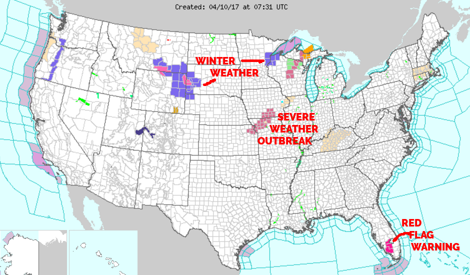
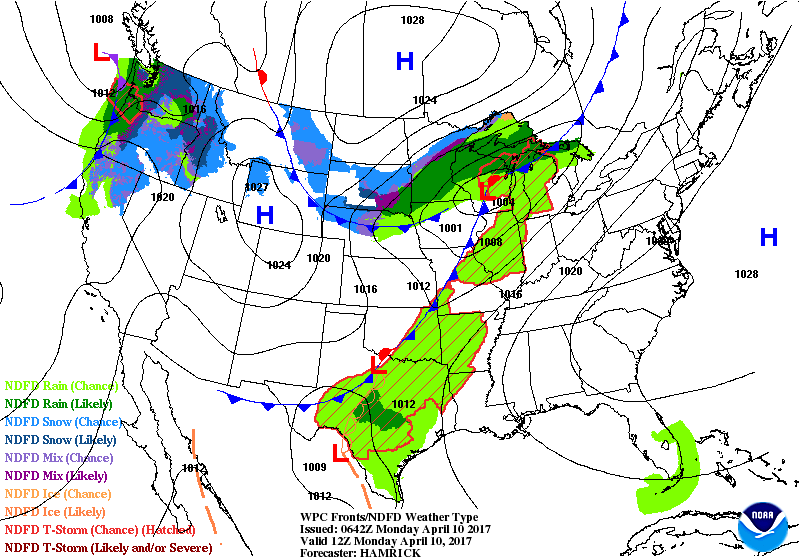
…A strong low pressure system will track north-eastward across the Upper Mississippi Valley and Great Lakes over the next few days, bringing a variety of weather impacts to the central and eastern U.S….
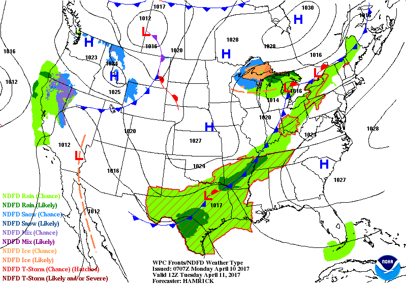
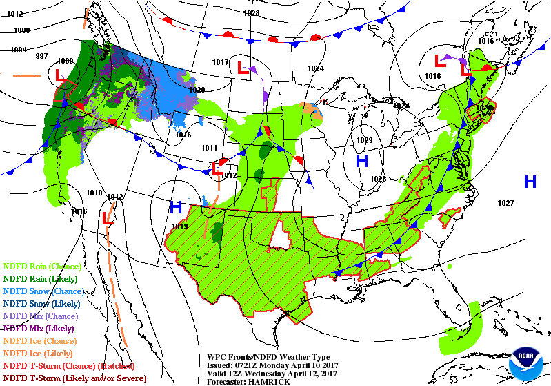
A strong cold front sinking southward from Canada will combine with another strong cold front tracking eastward across the Plains and Upper Mississippi Valley, evolving into a single frontal boundary during the first part of the overnight. This frontal system will slowly track across the Great Lakes and southwestward across the central U.S. into Monday. The northern extent of the front should reach the Northeast by Tuesday, while the southern extent will make it into the Lower Mississippi Valley during this time. Scattered showers and thunderstorms will continue to develop along and ahead of the frontal passage, with best coverage expected during the afternoon hours today and Monday. The Storm Prediction Center has outlined a Slight Risk area for severe thunderstorm development from the Upper Midwest southward into central Oklahoma for this afternoon into the overnight. They have also highlighted a Slight Risk area for central and northwest Texas, as well as for parts of the Upper Great Lakes region for Monday/Monday night. Please refer to the Storm Prediction Center Website (www.spc.ncep.noaa.gov) for more information. A strong surge of warm air from the Gulf of Mexico will be in place just ahead of the frontal zone, pushing well into the northern U.S. and helping to fuel this convective thunderstorm development. In fact, the Upper Great Lakes region could see near record breaking high minimum temperatures on Monday morning just before the cold front passage, with much of the Northeast seeing the same by Tuesday morning.
Across the north-central U.S., the remnants of the cold front sinking southward from Canada will allow for much colder temperatures to mix with precipitation chances, impacting the Northern Rockies and Northern Plains overnight, then shifting eastward into the Upper Great Lakes through Monday night. A combination of rain, snow, and even some ice will be possible in during that time. Accumulating snow will continue along the lee side of the Rockies and portions of the Northern Plains this evening and into tonight. Winter Weather Advisories and Winter Storm Warnings remain in effect across central and Southern Montana as well as northern Wyoming into the overnight as a result. Drier and windy conditions are expected elsewhere across the central and southern U.S. behind the frontal passage.
Another Pacific cold front will move inland and across the Pacific Northwest on Monday, bringing yet another round of coastal rain and mountain snow to much of this region and northern California tonight, then spreading inland into the Intermountain West and Northern Rockies over the next couple of days. The rain and snow amounts should be lighter than what was observed over the past few days.
Finally, for the eastern U.S. and Deep South, a high pressure ridge will remain in control for another couple of days. This will keep sunny to partly cloudy skies in place across the region, with warming conditions expected through the first part of the work week thanks to southerly flow. High temperatures in the 70s and 80s should be widely present.
LOCAL OUTLOOK
Dry and mild high pressure will dominate our local weather pattern through Tuesday. A weak cold front will move in from the west Tuesday night and will probably move through on Wednesday. High pressure from the north will move in for the latter half of the week.
Weather Almanac for April 10th (1872-2016)
Record weather events for this date in Macon County
Highest Temperature 86°F in Franklin in 2015
Lowest Temperature 18°F in Highlands in 1902
Greatest Rainfall 4.10 inches in Highlands in 1980
Greatest Snowfall No snowfall has been recorded in Macon County on this date since records started being kept in 1872
THREE DAY OUTLOOK
TODAY (Increased fire danger, outdoor burning is not recommended)
Sunny with highs in the mid 70s and calm wind early, increasing to come from the south 5 to 10 mph in the mid morning. Relative humidity values will also drop below 30% between noon and 6 pm.
TONIGHT
Mostly clear with lows in the mid to upper 40s. Winds out of the south becoming light and variable before midnight.
Mostly sunny with highs in the mid 70s and variable light winds.
TUESDAY NIGHT
Mostly cloudy with lows near 50 and calm winds. 30% chance of rain showers, mainly before 2 am.
WEDNESDAY
Partly sunny with highs in the mid 70s. 30% chance of showers, mainly between 11 am and 4 pm.
WEDNESDAY NIGHT
Partly cloudy with lows near 50.
HAZARDS
No hazardous weather is expected. There will be an increased fire danger due to relative humidity levels dropping below 30% between noon and 6 pm. Outdoor burning is not recommended.
As always, you can check to see what advisories, watches and warnings are in effect for Macon County by visiting http://is.gd/MACONWARN
MACON CALENDAR
If you have an event you wish to be added to this calendar, please send the information, along with a flyer in pdf format or a high quality photo, to [email protected]
There is no charge for civic, educational or non profit groups.
April 12
Bird walk along the Greenway. Meet at Big Bear Shelter parking area at 8:00 am.
APRIL 21 & 22
Franklin High School FFA Benefit Rodeo
Macon County Fairgrounds – 1436 Georgia Rd
Tickets available at the gate
$12 Adults
$6 Kids ages 5-10
Under 5 Free
Gates open at 6PM each night
Event starts at 8PM each night
Concessions available on site
Get there early for the best seating!
Saddle Bronc Riding
Bareback Riding
Calf Roping
Steer Wrestling
Ladies Breakaway Roping
Team Roping
Ladies Barrel Racing
Bull Riding
For more information, please visit the Facebook event page at https://www.facebook.com/events/1248793605202655/
SYRINGE EXCHANGE PROGRAM
On January 1, 2017, the Syringe Exchange Program of Franklin began operating a comprehensive harm reduction program to address the opioid epidemic that is effecting western NC. Opioid overdose reversal kits including naloxone are available free of charge. If you have any questions about our services or if you know someone interested in volunteering, please contact Stephanie Almeida at 828-475-1920.
Astronomy
Twilight Begins: 6:42 am
Sunrise: 7:08 am
Sunset 8:02 pm
Twilight Ends: 8:28 pm
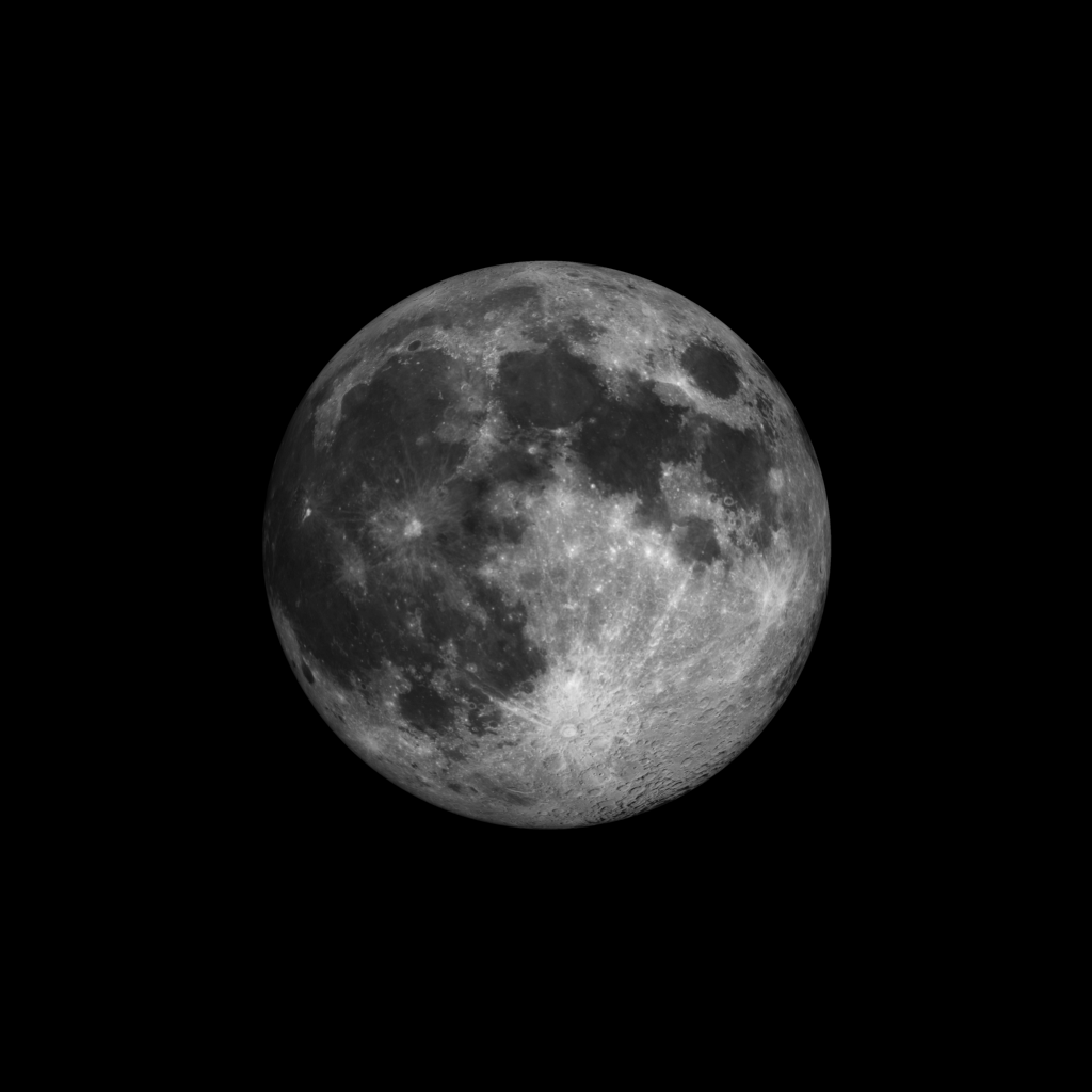
Moon Phase: Waxing Gibbous with 100% of the Moon’s visible disk illuminated
Moonset 7:01 am
Moonrise 7:40 pm
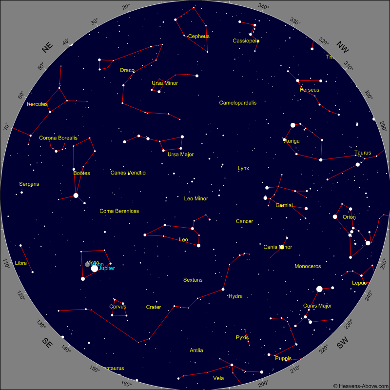
Evening Events and Planets
Chart shows sky at 10:30 pm tonight
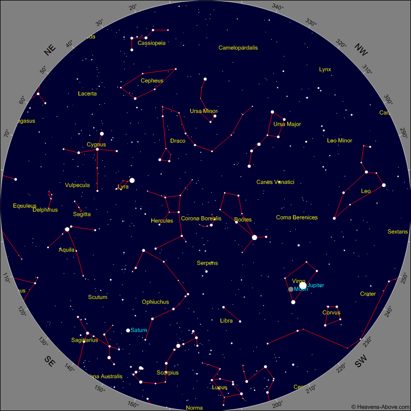
Morning Events and Planets
Chart shows sky at 4 am tomorrow morning
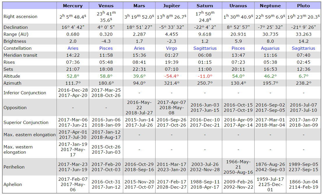
PLANET POSITION SUMMARY
Sky Guides for this week
Sky and Telescope Magazine
Astronomy Magazine
Earth Sky has an article on the eclipses of 2017. [LINK]
Heavens Above has an Android App that will assist you in observing the sky and even has a satellite tracker that will let you know when the International Space Station and dozens of other satellites are overhead. [LINK]
Stellarium is also an app that will assist you in observing the sky. It is available in both Android [LINK] and iOS versions. [LINK]
CROWD FUNDING OR DAY SPONSORSHIP OPPORTUNITIES
If you receive value from what Macon Media provides to the community, please consider becoming a supporter and contribute at least a dollar a month.
If you have a business or event you are interested in sponsorship opportunities or underwriting coverage, send an email to [email protected] for more information. Serious inquiries only.
Thank You to the people who have been sending in donations and those businesses who are underwriting coverage of news and events. You have kept Macon Media online. You have made it possible for Macon Media to begin purchasing state of the art equipment and begin work on building a real website with features not employed by any local news outlets.
You can find out more information on how to do that and some of what I plan to accomplish if I reach certain levels of funding at https://www.patreon.com/MaconMedia
Published at 4:18 am on April 8, 2017
#WNCscan #MaconWx #MaconSafety
Data and information sources: Sources (except where otherwise credited): heavens-above.com, National Centers for Environmental Prediction, The National Weather Service, National Oceanic Atmospheric Administration, Penn State University Electronic Wall Map, The State Climate Office of North Carolina, Storm Prediction Center, U.S. Naval Observatory, and the Weather Prediction Center.
Source: http://thunderpigblog.blogspot.com/2017/04/wx20170410.html


