


| Story Views | |
| Now: | |
| Last Hour: | |
| Last 24 Hours: | |
| Total: | |
Chet Raymo, “Squaring The Circle”

by Chet Raymo
“Here is a little story about the best and worst of Western civilization. It can be summarized in one word: square. Yep, that’s right. Square. The ninety degree corner, the plumb-bobbed line. Forget the squiggle, the wiggle, the curlicue, the arc. We’re talking orthogonality here. We’re talking perpendicularity.
I was flying across the country the other day at 37,000 feet. From the Mississippi to the Rockies, for a thousand miles, as far as the eye could see, the land was ruled into one-mile squares, as neat as the tiles on your kitchen floor.
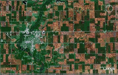
In 1785 the young Congress in Washington, at Thomas Jefferson’s request, decreed that public lands west of the Appalachians would be surveyed and sold in squares. Six-mile squares called townships. Each township divided into 36 one-mile squares called sections (usually bordered by roads). Sections divided into four quarters. Bingo! The checkerboard grid I observed from 37,000 feet. The 1785 survey plan ignored natural contours of the land, the sinuosity of shorelines and watercourses. Congress had one thing in mind: the efficient distribution of land. Esthetics didn’t enter into it. The goal was not to embellish nature, but to subdue it.
What I saw from the airplane is a classic example of Cartesian efficiency. One million square miles of geometric utility. A geographic straightjacket of mathematical lines. The rule of the square. We are richer and more powerful for it, of course, richer and more powerful than those cultures that are still “bogged down” in squiggles and curlicues. The squaring of the circle is the secret of our presumed success- the best and the worst of Western civilization.”
Source: http://coyoteprime-runningcauseicantfly.blogspot.com/2017/03/chet-raymo-squaring-circle.html
