

| Online: | |
| Visits: | |
| Stories: |

| Story Views | |
| Now: | |
| Last Hour: | |
| Last 24 Hours: | |
| Total: | |
Gigantic Waterway Under the Western US?

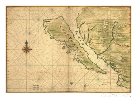
This 1650 map shows California to be an island. This supposed “misjudgment” by Europeans on a map, showing California as an island, was allegedly perpetuated by other map makers who continued the error. But, given the area from Imperial Valley, California and up through Death Valley (which was once filled with water) and into Western Nevada where Lake Lohantan once was (Lovelock Cave area), there are lots of reason to believe these areas were filled with water at one time which might have given the impression of California as an island, but the waterways dried up thousands of years ago.
Or, did they go undergound during seismic activity?
There is a theory floating around that there is an underground waterway that a single submarine can traverse from the California coastline to Nevada.
The Paiutes told a tale of the ancient giants who lived in Death Valley when there was water there. These giants lived up high in the mountains which were island tops in the water and they retreated into the caves up there as their housing.
The Native People explained in their legend that when the water “left,” the giants went into the caves and underground.
If you lost your water, wouldn't you chase it? Might they have adapted to living in cave systems? We already know they buried in caves, lived in caves, and mined in caves. This was their home already.
Perhaps their kind died off soon, without large amounts of humans to cannibalize. Perhaps they emerged from time to time to abduct their meals. Perhaps they lived on the large fish population underground and bats and occasional emerged to stalk other creatures for food source.
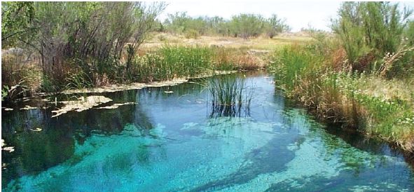
Source: This pristine spring in the unique environment of Ash Meadows in Nevada is hydrologically connected to Devil’s Hole, which is a nearly vertical cavern below the water table in southern Nevada. An endangered species, Devil’s Hole pupfish, has lived in Devil’s Hole pool for thousands of years. The water level in Devil’s Hole oscillated in response to the Denali Fault earthquake, which disrupted the spawning areas of the pupfish near the surface of the pool.
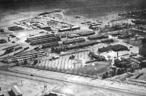
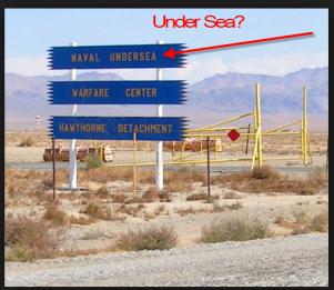
There has been talk for some time about there being a possible waterway that leads from the California coast, up to Nevada. One person points out that in Hawthorne, Nevada there is a Navy munitions storage site built in WWII Era.
The interesting talk here is of a shelf in the Pacific, under California, that allows submarines to travel under the US. Some reports have said as far as St. Louis, others have said from Puget Sound to under Idaho. The question becomes, if such a thing were possible, where does a submarine reemerge in the West? Does it come up at a lake and what lake would it possibly access?
Salt water would have to communicate with the lakes that the subs could emerge from, so if one believes the theory, the Great Salt Lake in Utah would seem the likely culprit. It is highly saline and large.
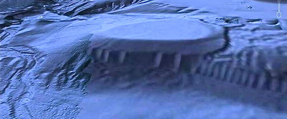
In the Malibu, California area near Point Dume, there appears from aerial views to be a opening under the shelf with pillars. This lends credence, some say, to the concept that submarines can go from California to Nevada underground. It is approximately 2000 feet down and three miles wide.
Experts all agree that it is a perfectly explainable geologic feature, not something constructed.
There is a place in the Phillipines that has an underground river that runs 5 miles to the sea: The underground Cabayugan river long remained hidden from the Western world and was once held a mythical status, the only evidence of it being the stories and rumors of the native people of the island. In 1898, the American Zoologist Dean C. Worcester spent a good deal of time studying the fauna of Palawan and made mention of the mysterious river, saying, “If accounts are to be believed, of a lake opening to the sea by a subterranean river.”
That river, however, is not a navigable waterway that runs the length from California Coastline to Nevada's desert. That would be exceptional beyond compare, especially given the effects of earthquakes on it and wherever its outlet is in the desert.
Interestingly, one outdoor adventurer I know mentioned drillings abandoned in California that led one to come to the conclusion they had hit an underwater lake or river. In fact, this person was in talks about the potential to be the first to raft that waterway. Should such a thing come to be, I'd certainly want to cover that happening!
Being involved in the oil business, I'd say the gamma ray, electrical and radiation logs would should whether there was a vast waterway down there or not and oil producers do not work on a lease without logs to tell them what is below the surface.
What this does have me considering is the underground in the west. We find giants in caves. We find their traces of mining. We hear tales of them being trapped and killed in caves. And, some believe they still live in them. Now, the underground West gets exciting when we think caves might still be a refuge!
More info:
Hawthorn Ammunitions Complex
More on Lake under Nevada
Extensive post about the geological explanations
Source: http://www.ghosthuntingtheories.com/2015/02/gigantic-waterway-under-western-us.html
