(Before It's News)
Vatic Note: Well, normally I find something and go down that rabbit hole and take it even further, but American Action Report has now done the same thing on one of our blogs. It was further researched and he came up with a startling conclusion or possible conclusion, that I missed completely on the orginal article we did.
Its so fascinating that I decided to put it up for your consideration. After going down this rabbit hole, he found all this… If we take a look at where this continent may well have been originally, it would explain some of the migration patterns of some countries.
It could be these people were previously Atlantians. How cool is that? I was thinking about the celts which have always been touted as the remnant of Atlantis. If what he says below is true, than that could be a reality. Good job, Dr. Mills.
Can Antarctica be the Lost Continent Atlantis?
http://americanactionreport.blogspot.tw/2013/03/can-antarctica-be-lost-continent.html
by Dr. GW Mills, American Action Report, Taiwan
Monday, March 18, 2013
Here are a few comments on a Vatic Report article concerning the Theory of Continental Drift and the possible whereabouts of Atlantis.
Over the past hundred years or so, the ocean floor has been so thoroughly mapped that we can say with reasonable certainty that Atlantis, if it ever existed, is not on the ocean floor.
A recent Vatic Report article suggests that Atlantis may be buried beneath two miles of ice on the South Pole. As per the Theory of Continental Drift (and perhaps Polar Shift), Atlantis is said to have drifted, over a brief span of time, to where the South Pole now lies.
The fossil record supports this theory. Fossilized leafy plants have been found under miles of Antarctic ice. Since leafy plants can’t thrive in an area that receives only six months of sunlight a year, either the continent or the globe must have shifted.
When comparing centuries-old maps to places today, we must take into account both the cartographic skills of the day and what could have been actually known at the times the maps were drawn. It’s useful, then, to make a few comparisons to determine just how closely two maps of places can resemble each other before we can suppose that the two maps must represent the same place.
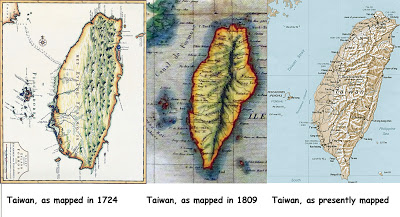
Below are three maps of Taiwan:
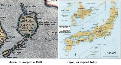
Now let’s compare two maps of Japan:
Below are four maps to compare. One (A) is the Piri Reis map of Terra Australis Incognito (Southern Unknown Land), which, according to the 1513 map, was located where Antarctica is located today. The next (B) is Antarctica as it would appear without ice. Map (C) is an 1891 depiction of Atlantis, drawn from descriptions in myth and legend. It’s worth noting that the map was drawn well before the earliest exploration of Antarctica. Map (D) is Antarctica as it is mapped today.
As you can see, the maps of Atlantis, Antarctica, and Terra Australis Incognita are as close a match to each other as the three maps of Taiwan. In fact, they more closely resemble each other than the two maps of Japan. This doesn’t prove that Atlantis, Antarctica, and Terra Australis Incognita are the same place. It does, however, help to make a case for the belief.
Skeptics would have a hard time making a case for a theory that Patroclus Kampanakis’s 1891 map of Atlantis was a deliberate rendering of the Piri Reis map or Antarctica. The Piri Reis map had been unknown to the West, lost, and not discovered until 1929. (source)
Accurate maps of Antarctica were still later in coming. According to Paul Cooper of British Antarctic Survey’s Mapping and Geographic Information Centre (MAGIC), “It wasn’t until 1983 that the first broadly accurate map of Antarctica was produced. That was the first time a map brought together enough information for us to be pretty sure that we’d got all the major features in the right places.” (source) (emphasis added)
The importance of this issue to our time is the understanding that it may shed some light on the origins of today’s civilizations. There may well have been a highly advanced civilization on Earth more than 12,000 years ago. The survivors of whatever destroyed that early civilization may have contributed to “civilization” as we know it today.
Posted by American Action Report at 10:09 AM
The article is reproduced in accordance with Section 107 of title 17 of the Copyright Law of the United States relating to fair-use and is for the purposes of criticism, comment, news reporting, teaching, scholarship, and research.
Source:


The map shown here as part of the Piri Reis Map is not part of the Piri Reis Map at all. The Piri Reis Map does not show “Terra Australis Incognita”. The map shown is a portion of the Orontius Finaeus Map of 1531. The maps look nothing alike. On the O.F. map, just below the title “Terra Austalis Incognita” are the words, “Terra Australis recenter inventa sed nondum plene cognita”, which means “Southern land found recently but not fully known”. It was drawn from various sightings at various disconnected (or geographically distal) points by sailors as reported over the years.
For example, no land mass comes that close to the Straight of Magellan at the tip of South America, but on many maps at the time, including the O.F. map, Tierra del Fuego, which was coasted by Magellan himself in 1520, was shown and thought to be the northern coast of Terra Australis Incognito. We now know that it is an island. It is even labelled as Tierra del Fiego on the Jodocus Hondius Map of 1608, which shows is at the northern coast of Terra Australis Incognito. Farther east (or west if you like), the coast of Terra Australis Incognita from the O.F. map matches up remarkably well (for map-making skills of the day) with the northern coast of Australia at the Carpentaria Gulf, including its location in relation to the Island of Java. Much of the rest of the “not fully known” continent is simply drawn in to fill in the map (obviously, as in the example of Tierra del Fuego which is drawn as part of a continent but is clearly an island).
This is in line with the thinking of the day. After being able to calculate with surprising accuracy that the world is a sphere (and how large it is), and knowing that there were lands in the north, it was believed that there must be land in the south in order to balance it out. It turns out they were correct, but were simply off with their efforts in filling in the gaps on the map. If you can superimpose the continent of Antarctica onto Terra Australis from the O.F. map, it is easy to see that Terra Australis contains 5 times the land mass of Antarctica as known today. This isn’t surprising knowing that the Fine connected the shorelines of what we now know as Australia with Tierra del Fuego and likely other islands in between that he found the locations of, which were sighted from a distance and assumed to be part of a land mass.
Patroklos Kampanakis’ map is a fictional, theoretical map that he drew out a his theory that Atlantis was a continent in the Atlantic Ocean between North Africa and South America. He didn’t draw it from any sources he had, and he says what it is in his book (in which the map appears), “The Procataclysm Communication of the Two Worlds via Atlantis”, written in 1893.
Dr. Mills produced a reasonably well thought out but poorly researched article (all the info I wrote can be found in 10 minutes or less on Google, though I’m personally well acquainted with ancient maps).
Sincerely,
ShawnO
Professional Surveyor and Cartographer