


| Story Views | |
| Now: | |
| Last Hour: | |
| Last 24 Hours: | |
| Total: | |
Storm Study Reveals A Sting In The Tail

Meteorologists have gained a better understanding of how storms like the one that battered Britain in 1987 develop, making them easier to predict.
The Great Storm of 1987, which famously caught out weatherman Michael Fish, left a trail of destruction when winds up to 120mph swept across southern England and northern France, killing 22 people. More recently, gusts of 100mph in January 2012 damaged buildings in Scotland and cut power to tens of thousands of homes.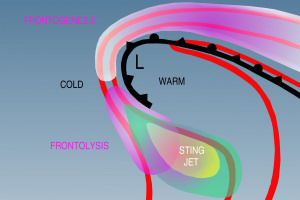
Credit: University of Manchester
Such storms are characterized by severe gale-force winds known as sting jets that descend from several kilometers above the surface.
“Sting jets are these regions of strong winds that tend to occur to the south and south-east of the low centre,” explained Professor David Schultz, who led the research in Manchester’s School of Earth, Atmospheric and Environmental Sciences.
“These winds are generated from a descending motion of air that is several kilometres above the surface to the north and north-east of the depression. While the front is intensifying, in a region known as frontogenesis, the winds are steadily rising then, in a region known as frontolysis at the tail end of the front, the winds start descending. If the descent is strong enough and other conditions are appropriate, the strong winds can reach the surface in this place called the sting jet.”
The researchers, whose findings were published in the journal Weather and Forecasting, took to the skies to fly through a developing storm and measure the strength and direction of the winds.
“The irony is that the winds are strongest in the cyclone where the front is weakening most intensely.
“Our findings are significant because they tell us exactly where we can expect these winds and give forecasters added knowledge about the physical processes that are going on to create this region of strong winds.”
Contacts and sources:
Aeron Haworth
Faculty of Engineering and Physical Sciences
The University of Manchester
Citation: ‘Using Frontogenesis to Identify Sting Jets in Extratropical Cyclones,’ published in Weather and Forecasting, by David Schultz, The University of Manchester, and Joseph Sienkiewicz, NOAA/NWS/NCEP/Ocean Prediction Center, Maryland
2013-05-03 13:30:46
Source: http://nanopatentsandinnovations.blogspot.com/2013/05/storm-study-reveals-sting-in-tail.html
Source:
