


| Story Views | |
| Now: | |
| Last Hour: | |
| Last 24 Hours: | |
| Total: | |
Hadley Crater Provides Deep Insight Into Martian Geology

Recently engaged in providing support to the successful landing of NASA’s Mars Science Laboratory’s Curiosity rover, ESA’s Mars Express has now returned to its primary mission of studying the diverse geology and atmosphere of the ‘Red Planet’ from orbit.
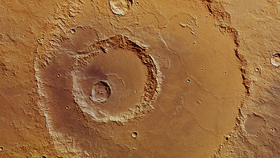
Credits: ESA/DLR/FU Berlin (G. Neukum)
Earlier this year, the spacecraft observed the 120 km wide Hadley Crater, providing a tantalising insight into the martian crust. The images show multiple subsequent impacts within the main crater wall, reaching depths of up to 2600 m below the surrounding surface.
This computer-generated perspective view of Hadley Crater was created using data obtained from the High-Resolution Stereo Camera (HRSC) on ESA’s Mars Express. Centred at around 19°S and 157°E, this image has a ground resolution of about 19 m per pixel. The ejecta blanket emanating from the deep crater in the middle of the image shows evidence for volatiles, possibly water ice, while the main crater rim to the top (south) of the image shows evidence for so-called “mass wasting”. This is a geomorphic process by which surface materials can move down a slope under the force of gravity. In this case, this process made the southern side of the crater shallower than its northern counterpart.

Credits: ESA/DLR/FU Berlin (G. Neukum)
This region imaged on 9 April 2012 by the High Resolution Stereo Camera on Mars Express shows the crater which lies to the west of the Al-Qahira Vallis in the transition zone between the old southern highlands and the younger northern lowlands.
Hadley is named after the British lawyer and meteorologist George Hadley (1685-1768) whose name was also given to the ‘Hadley cell’, a circulation system in the Earth’s atmosphere, which transports heat and moisture from the tropics up to higher latitudes.
The images show that Hadley Crater was struck multiple times by large asteroids and/or comets after its initial formation and subsequent infilling with lava and sediments.
Some of these later impacts have also been partly buried, with subtle hints of a number of crater rims to the west (top), and wrinkle ridges to the north (right side) of the main crater floor as shown in the first image at the top of the page.
Hadley Crater in broader context. The smaller rectangle shows the region covered in this ESA Mars Express HRSC image release. Hadley Crater is west of the Al-Qahira Vallis in the transition zone between the old, southern highlands and the younger northern lowlands.

Credits: NASA MGS MOLA Science Team
![]()
Again, in the first image (top of the page), the southern (left) side, the crater appears shallower than the opposite side. This difference can be explained by an erosion process known as mass wasting. This is where surface material moves down a slope under the force of gravity.
Mass wasting can be initially started by a range of processes including earthquakes, erosion at the base of the slope, ice splitting the rocks or water being introduced into the slope material, In this case there is no clear indication which process caused it, or over what timescales this may have occurred.
This computer-generated perspective view was created using data obtained from the High-Resolution Stereo Camera (HRSC) on ESA’s Mars Express. Centred at around 19°S and 157°E, the image has a ground resolution of about 19 m per pixel. This view shows several of the later craters within the main perimeter of Hadley. Fluidised ejecta can be seen both in the bottom right and top left craters, the latter crater reaching a depth of around 2600 m.

Credits: ESA/DLR/FU Berlin (G. Neukum)
Of particular interest to scientists studying the geology of Mars are the ejecta of the smaller craters within Hadley. Two of them, one to the west (top), and the deepest one in the middle of the first image, show evidence for volatiles, possibly water ice beneath the surface.
With the impact that forms the craters, this ice would mix with surrounding materials to form a kind of ‘mud’, which would then spread over the surface as ejecta.
This colour-coded plan view is based on a digital terrain model of the region, from which the topography of the landscape can be derived. The colour coding highlights the depth of the central impact crater, reaching down almost 2600 m compared to the region surrounding Hadley Crater itself. Deep craters like these provide scientists with a view through the historical timeline of Mars’ formation. Centred at around 19°S and 157°E, the image has a ground resolution of about 19 m per pixel.

Credits: ESA/DLR/FU Berlin (G. Neukum)
Scientists believe these volatiles which were excavated by the impacts, may indicate the presence of ice to a depth of around hundreds of metres, this being the difference in depth between the surface and the depths of the two craters.
This deep view into the martian crust within the walls of Hadley Crater provides scientists an insight into the history of Mars. A history which rovers like those currently on the Red Planet and others which follow will doubtless continue to investigate.
Hadley Crater imaged during revolution 10572 on 9 April 2012 by ESA’s Mars Express using the High-Resolution Stereo Camera (HRSC). Data from HRSC’s nadir channel and one stereo channel are combined to produce this anaglyph 3D image that can be viewed using stereoscopic glasses with red–green or red–blue filters. The image shows the buried craters within the main Hadley Crater perimeter, as well as wrinkle ridges, created when the crust cools and contracts. Centred at around 19°S and 157°E, the image has a ground resolution of about 19 m per pixel.

Credits: ESA/DLR/FU Berlin (G. Neukum)
