
| Visitors Now: | |
| Total Visits: | |
| Total Stories: |

| Story Views | |
| Now: | |
| Last Hour: | |
| Last 24 Hours: | |
| Total: | |
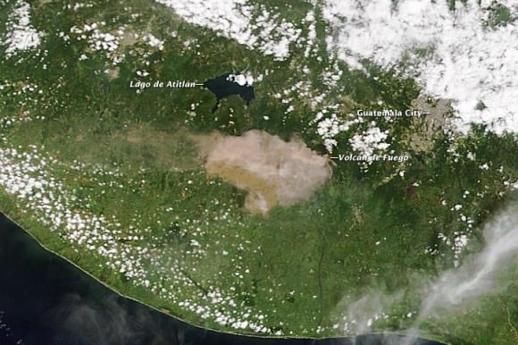
Satellite View of Guatemalan Volcano Erupting
A natural-color image captured the eruption of Volcan de Fuego as it occurred. Credit: NASA/Moderate Resolution Imaging Spectroradiometer (MODIS) aboard the Terra satellite.
One of Central American’s most active volcanos erupted on September 13th, 2012 prompting officials to evacuate 35,000 residents in Guatemala. The Volcan de Fuego, or Fire Volcano, began belching out ash at 10 a.m. local time with ash now falling up to 40 kilometers (25 miles) from the volcano. Residents within 20 kilometers (12 miles) of the volcano were being removed from the area in buses and cars.
(…)
Read the rest of Satellite View of Guatemalan Volcano Erupting (111 words)
© nancy for Universe Today, 2012. | Permalink | One comment |
Post tags: Natural Disasters, satellite imagery, Volcanos
Feed enhanced by Better Feed from Ozh
2012-09-15 20:05:06
Source: http://www.universetoday.com/97380/satellite-view-of-guatemalan-volcano-erupting/
Source:


