
| Visitors Now: | |
| Total Visits: | |
| Total Stories: |

| Story Views | |
| Now: | |
| Last Hour: | |
| Last 24 Hours: | |
| Total: | |
Satellites Provide 3-D Views and More of Hurricane Sandy
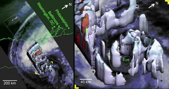
Hurricane Sandy as viewed by the TRMM Precipitation Radar at 2:20 EDT on Oct. 28, 2012. Credit: NASA
Satellite imagery and data has been invaluable in predicting the path and intensity of storms like Hurricane Sandy. Satellites like NASA’s Tropical Rainfall Measuring Mission (TRMM) can measure rainfall rates and cloud heights in tropical cyclones, and was used to create a 3-D image, above, to allow forecasters to look inside the hurricane, and predict fairly spot-on what locations would be affected the worst. There’s even a 3-D video view from the CloudSat satellite, and much more, including a stunning wind map, and this round-up from JPL of various satellite views of the storm. You can also see a slideshow of NASA satellite images and videos on the NASA Goddard Flickr site.
This exemplifies just one reason why space exploration is important, and why people are maybe now starting to realize how our failure to plan ahead and invest in weather satellites may become a problem. Without those eyes in the sky we are blind to the minute-to-minute and hour-to-hour development of storms and weather, not to mention overall study of the climate.
Below is a stunning high-speed satellite view from the GOES-14 satellite:
(…)
Read the rest of Satellites Provide 3-D Views and More of Hurricane Sandy (48 words)
© nancy for Universe Today, 2012. | Permalink | No comment |
Post tags: Earth Observation, Hurricane Sandy, hurricanes, Natural Disasters, Satellites
Feed enhanced by Better Feed from Ozh
2012-10-30 00:45:24
Source: http://www.universetoday.com/98249/satellites-provide-3-d-views-and-more-of-hurricane-sandy/
Source:


