


| Story Views | |
| Now: | |
| Last Hour: | |
| Last 24 Hours: | |
| Total: | |
Amazing Map Is Made Up Of Everyone in the U.S. and Canada

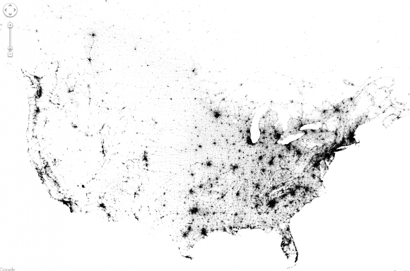
Zoomable map of the US and Canada pinpoints everyone with a dot. (Credit: Brandon Martin-Anderson/Census Dotmap)
Now this is something different: an interactive and zoomable map of the United States and Canada, made not from political boundaries or geographic landforms but rather of tiny dots — 341,817, 095 of them, to be exact — each one representing an individual person counted in the 2010 (US) and 2011 (Canada) censuses. There’s no other features on this map except those dots, each randomly placed within the regional blocks used by the census, yet we still end up with a very recognizable structure.
So if you were listed in either of these censuses, you helped to make this map!
(…)
Read the rest of Amazing Map Is Made Up Of Everyone in the U.S. and Canada (185 words)
© Jason Major for Universe Today, 2013. | Permalink | No comment |
Post tags: Canada, census, dotmap, interactive, map, US, zoom
Feed enhanced by Better Feed from Ozh
2013-01-14 15:31:29
Source: http://www.universetoday.com/99432/amazing-map-is-made-up-of-everyone-in-the-u-s-and-canada/
Source:
