


| Story Views | |
| Now: | |
| Last Hour: | |
| Last 24 Hours: | |
| Total: | |
5 Landsat Pictures That Changed the World

Turn a camera to a location for four decades, and you can see a lot of change. Streets appear or disappear. Trees grow and eventually, die. Houses spring up and slowly decay.
Landsat is the longest-running Earth observation program, with four decades of observations behind it. Today, to celebrate the launch of Landsat 5 on this day in 1984, here are five Landsat images that helped us better understand the Earth and at times, how humans affect its environment.
Mount St. Helens
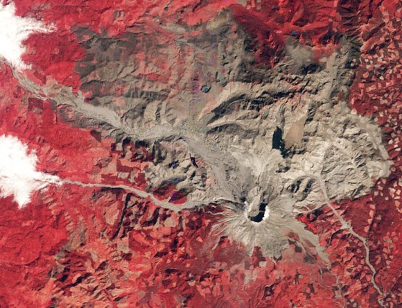
Mount St. Helens shortly after its eruption in 1980. Credit: Landsat/USGS
(…)
Read the rest of 5 Landsat Pictures That Changed the World (482 words)
© Elizabeth Howell for Universe Today, 2013. |
Permalink |
No comment |
Post tags: Landsat 5, landsat 7, landsat program
Feed enhanced by Better Feed from Ozh
2013-03-01 11:02:14
Source: http://www.universetoday.com/100171/5-landsat-pictures-that-changed-the-world/
Source:
