


| Story Views | |
| Now: | |
| Last Hour: | |
| Last 24 Hours: | |
| Total: | |
Explosive Crater Twins on Mars

read more at Anne’s Astronomy News http://annesastronomynews.com/
Dramatic underground explosions, perhaps involving ice, are responsible for the pits inside two large martian impact craters, here imaged by ESA’s Mars Express on 4 January.
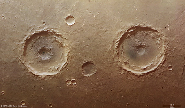
The ‘twin’ craters are in the Thaumasia Planum region, a large plateau that lies immediately to the south of Valles Marineris, the largest canyon in the Solar System.
The northernmost (right) large crater in this scene was officially given the name Arima in early 2012, but the southernmost (left) crater remains unnamed. Both are just over 50 km wide and display intricate interior features. The southernmost crater is also presented here in a perspective view, revealing its complex characteristics in detail. Multiple terraces slump from the crater walls onto a flat floor, but perhaps the most striking feature is the central pit, a feature it shares with Arima crater to its north.

A perspective view of a 50 km diameter crater in Thaumasia Planum. The image was made by combining data from the High-Resolution Stereo Camera on ESA’s Mars Express with digital terrain models. The image was taken on 4 January 2013, during orbit 11467, and shows a close up view of the central ‘pit’ of this crater, which likely formed by a subsurface explosion as the heat from the impact event rapidly vaporized water or ice lying below the surface. Image Credit: ESA/DLR/FU Berlin (G. Neukum)
Central pit craters are common on Mars, as well as on the icy moons orbiting the giant planets in our Solar System. But how did they form?
When an asteroid hits the rocky surface of a planet, both it and the surface are compressed to high densities. Immediately after the impact, the compressed regions rapidly depressurise, exploding violently. In low-energy impacts, a simple bowl-shaped crater results. In more dramatic events, larger craters are produced with more complex features, such as uplifted central peaks or sunken pits.

The area imaged on 4 January 2013, during orbit 11467, lies just south of the Coprates Catena region of Vallis Marineris, in Thaumasia. The smaller rectangle shows the region covered in this ESA Mars Express High-Resolution Stereo Camera image release highlighting two 50 km-wide craters. The northernmost is called Arima, while the southernmost remains unnamed. Image Credit: NASA MGS MOLA Science Team
One idea for central pit formation is that when rock or ice melted during the impact drains away through fractures beneath the crater, it leaves a pit.
Another theory is that subsurface ice is rapidly heated, vaporizing in an explosion. As a result, the rocky surface is excavated forming an explosive pit surrounded by rocky debris. The pit is in the center of the main crater, where most of the impact energy was deposited.

This color coded overhead view is based on an ESA Mars Express High-Resolution Stereo Camera digital terrain model of the Thaumasia Planum region on Mars at approximately 17°S / 296°E. The image was taken during orbit 11467 on 4 January 2013. The color coding reveals the relative depth of the craters, in particular the depths of their central pits, with the left-hand crater penetrating deeper than the right (Arima crater). Image Credit: ESA/DLR/FU Berlin (G. Neukum)
Many neighboring small impact craters also show evidence for subsurface water or ice at the time of impact as evidenced by their ‘rampart’ ejecta blankets.
Ejecta blankets are debris deposits surrounding the crater, excavated from inside the crater during its formation. They have petal-like lobes around their edges: these result from liquid water bound up in the ejected material, allowing it to flow along the surface and giving it a fluid appearance.

Part of the Thaumasia Planum region imaged during revolution 11467 on 4 January 2013 by ESA’s Mars Express using the High-Resolution Stereo Camera (HRSC). Data from HRSC’s nadir channel and one stereo channel have been combined to produce this anaglyph 3D image that can be viewed using stereoscopic glasses with red–green or red–blue filters. Centered at approximately 17°S / 296°E longitude, the image has a ground resolution of about 25 m per pixel. The image highlights the Arima crater (right) and its unnamed ‘twin’ crater to the left, and the central pit features of both craters. Image Credit: ESA/DLR/FU Berlin (G. Neukum)
Impact craters like these can thus provide windows into the past of a planet’s surface. In this case, they provide evidence for the Thaumasia Planum region having once hosted plentiful subsurface water or ice that was liberated during impact events both small and large.
Source: The European Space Agency (ESA)
n/a
2013-04-12 11:31:29
Source: http://annesastronomynews.com/explosive-crater-twins-on-mars/
Source:
