
| Visitors Now: | |
| Total Visits: | |
| Total Stories: |

| Story Views | |
| Now: | |
| Last Hour: | |
| Last 24 Hours: | |
| Total: | |
NASA’s LADEE Lunar Probe Set for Spectacular Science and September Night Launch – Visible to Millions and Millions

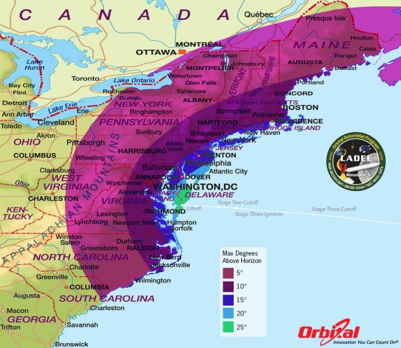
LADEE Minotaur V Launch – Maximum Elevation Map
The LADEE nighttime launch will be visible to millions of spectators across a wide area of the Eastern US -weather permitting. This map shows the maximum elevation (degrees above the horizon) that the Minotaur V rocket will reach during the Sep. 6, 2013 launch depending on your location along the US east coast. Credit: Orbital Sciences
A spectacular nighttime blastoff blazing a historic trail to the Moon is set to soar in two weeks time when NASA’s LADEE spacecraft lifts off from the Eastern Shore of Virginia at NASA’s Wallops Flight Facility on Wallops Island – from America’s newest spaceport.
NASA’s Lunar Atmosphere and Dust Environment Explorer (LADEE) Observatory will thunder to space at 11:27 p.m. Friday, Sept. 6, from the commercial Mid-Atlantic Regional Spaceport (MARS) launch complex 0B at NASA’s Wallops Island facility atop the maiden flight of the new, solid fueled Minotaur V rocket developed by Orbital Sciences Corp.
LADEE’s late night launch will be absolutely spectacular and visible to tens of millions of spectators up and down the US East coast and interior areas stretching into (…)
Read the rest of NASA’s LADEE Lunar Probe Set for Spectacular Science and September Night Launch – Visible to Millions and Millions (1,049 words)
© Ken Kremer for Universe Today, 2013. |
Permalink |
No comment |
Post tags: Apollo misisons, LADEE, Minotaur V rocket, Moon, NASA, NASA Wallops, Orbital Sciences Corporation, Wallops Flight Facility
Feed enhanced by Better Feed from Ozh
Source: http://www.universetoday.com/99284/nasas-ladee-lunar-probe-set-for-spectacular-science-and-september-night-launch-visible-to-millions-and-millions/


