
| Visitors Now: | |
| Total Visits: | |
| Total Stories: |

| Story Views | |
| Now: | |
| Last Hour: | |
| Last 24 Hours: | |
| Total: | |
Antarctic Sea Ice Takes Over More Of The Ocean Than Ever Before

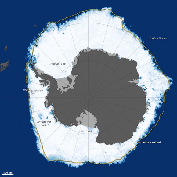
Antarctica’s sea ice on Sept. 22, 2013. Scientists say there was more ice on the ocean then than in any time in recorded satellite history. Data came from the Advanced Microwave Scanning Radiometer 2 (AMSR2) sensor on Japan’s Global Change Observation Mission 1st-Water (GCOM-W1) satellite. You can see the land in dark gray and ice shelves in light gray. The yellow line represents the average distribution of sea ice between 1981 and 2000. Credit: NASA/Jesse Allen, using data from the Advanced Microwave Scanning Radiometer 2 (AMSR2) sensor on the Global Change Observation Mission 1st-Water (GCOM-W1) satellite.
Antarctica’s sea ice is creeping further out in the ocean! New data from a Japanese satellite shows that sea ice surrounding the southern continent in late September reached out over 7.51 million square miles (19.47 million square kilometers).
The extent — a slight increase over 2012′s record of 7.50 million square miles (19.44 million square km) — is the largest recorded instance of Antarctica sea ice since satellite records began, NASA said. Data was recorded using the Advanced Microwave Scanning Radiometer 2 (AMSR2) sensor on the Global Change Observation Mission 1st-Water (GCOM-W1) satellite.
“While researchers continue to study the forces driving the growth in sea ice extent, it is well understood that multiple factors—including the geography of Antarctica, the region’s winds, as well as air and ocean temperatures—all affect the ice,” NASA stated.
(…)
Read the rest of Antarctic Sea Ice Takes Over More Of The Ocean Than Ever Before (140 words)
© Elizabeth Howell for Universe Today, 2013. |
Permalink |
No comment |
Post tags: antarctica, glacier, land ice, sea ice
Feed enhanced by Better Feed from Ozh
Source: http://www.universetoday.com/105952/antarctic-sea-ice-takes-over-more-of-the-ocean-than-ever-before/


