| Online: | |
| Visits: | |
| Stories: |

| Story Views | |
| Now: | |
| Last Hour: | |
| Last 24 Hours: | |
| Total: | |
1st Images from New NASA/JAXA GPM Rainfall Measuring Satellite Capture Tropical Cyclone in 3D

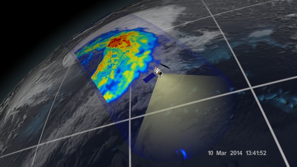
An extra-tropical cyclone seen off the coast of Japan, March 10, 2014, by the GPM Microwave Imager. The colors show the rain rate: red areas indicate heavy rainfall, while yellow and blue indicate less intense rainfall. The upper left blue areas indicate falling snow. Credit: NASA/JAXA
Weather researchers worldwide now have the ability to capture unprecedented three-dimensional images and detailed rainfall measurements of cyclones, hurricanes and other storms from space on a global basis thanks to the newest Earth observing weather satellite – jointly developed by the US and Japan.
NASA and the Japan Aerospace Exploration Agency (JAXA) have now released the first images captured by their Global Precipitation Measurement (GPM) Core Observatory satellite.
GPM soared to space on Feb. 27, exactly one month ago, during a spectacular night launch from the Japanese spaceport at the Tanegashima Space Center on Tanegashima Island off southern Japan. (…)
Read the rest of 1st Images from New NASA/JAXA GPM Rainfall Measuring Satellite Capture Tropical Cyclone in 3D (405 words)
© Ken Kremer for Universe Today, 2014. |
Permalink |
No comment |
Post tags: cyclones, Global Precipitation Measurement (GPM) satellite, GPM, japan space program, Japanese Aerospace Exploration Agency, JAXA, NASA, NASA Goddard Spaceflight Center, tropical cyclones
Feed enhanced by Better Feed from Ozh
Source: http://www.universetoday.com/110743/1st-images-from-new-nasajaxa-gpm-rainfall-measuring-satellite-capture-tropical-cyclone-in-3d/


