


| Story Views | |
| Now: | |
| Last Hour: | |
| Last 24 Hours: | |
| Total: | |
Satellite Views Show Hurricane Matthew Moving Towards U.S.

As Hurricane Matthew approaches the east coast of Florida, the evacuation of hundreds of thousands of people is taking place in Florida and South Carolina. Forecasters say the conditions appear to be favorable for the storm to restrengthen after it caused major damage to western Haiti and eastern Cuba. Matthew is now heading toward Florida, bringing with it the potential for heavy rain, storm surges and hurricane-force winds. The expected maximum sustained winds could be 130 mph (210 km/hr), and it could be the strongest hurricane to hit the region in 11 years
The National Hurricane Center said “Matthew is moving toward the northwest near 12 mph (19 kph), and this motion is expected to continue during the next 24 to 48 hours. On this track, Matthew will be moving across the Bahamas through Thursday, and is expected to be very near the east coast of Florida by Thursday evening, Oct. 6.”
The image above was taken by NASA’s Terra satellite on October 4, 2016, showing the hurricane over the eastern tip of Cuba and the eastern-most extent over Puerto Rico. Reports say it was the strongest storm to hit the Caribbean nation in more than 50 years.
Cameras on board the International Space Station captured these views of Hurricane Matthew today (October 5) as the now Category 3 storm moved to the north of Cuba:
NASA’s Kennedy Space Center released a statement that they closed at 1 p.m. today due to the approach of the hurricane, with essential personnel preparing facilities for the storm’s arrival.
Stu Ostro, a senior meteorologist at The Weather Channel, tweeted a satellite image of the hurricane, which has gone viral, which some say shows a face with a fiery eye, teeth and a sinister smile.
Sinister-looking face of #HurricaneMatthew at landfall in #Haiti [Un-doctored #weather #satellite image] pic.twitter.com/hrviDVuJ3R
— Stu Ostro (@StuOstro) October 4, 2016
WeatherUnderground is tracking the storm and as of 6:00 pm ET on October 5, this was the projected path of the storm. You can click the image (or this link) to get the current tracking data on WeatherUnderground.
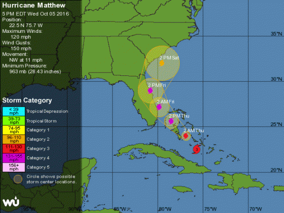
Projected path for Hurricane Matthew as of October 5, 2016. Click for updated map on WeatherUnderground.com.
This animation of NOAA’s GOES-East satellite imagery from Oct. 3 to Oct. 5 shows Hurricane Matthew make landfall on Oct. 4 in western Haiti and move toward the Bahamas on Oct. 5.
NOAA said tropical storm or hurricane conditions could affect South Carolina and North Carolina later this week or this weekend, even if the center of Matthew remains offshore, adding that “it is too soon to determine what, if any, land areas might be directly affected by Matthew next week. At a minimum, dangerous beach and boating conditions are
likely along much of the U.S. east coast during the next several days.”
For additional information see:
NASA’s page on Hurricane Matthew
NASA’s Earth Observatory website
National Hurricane Center
The post Satellite Views Show Hurricane Matthew Moving Towards U.S. appeared first on Universe Today.
Source: http://www.universetoday.com/131244/satellite-views-show-hurricane-matthew-moving-towards-us/
