


| Story Views | |
| Now: | |
| Last Hour: | |
| Last 24 Hours: | |
| Total: | |
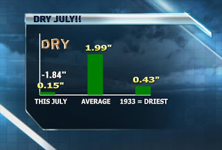
The Record Setting Pace Contines this Month

Written by John DiPasquale:
Wow! What a stat above! We are on pace for it to be the driest July ever recorded here in Rochester with just a week & a half to go before we exit this month.
Not much rain to write home about over the last 24 hours, except there was at least a tenth to a quarter of an inch across parts of the Finger Lakes, mainly the Southern Finger Lakes. Unfortunately, just a trace here in Rochester over the last 24 hours. Low pressure aloft & down at the ground down to the south responsible for the showers will slowly continue to pull away & weaken, which will allow high pressure to build in from the northwest later today & more so tonight & tomorrow. This will mean some developing sun later today, & a very nice summer’s day Saturday with highs to begin the weekend between 80 & 85.
On Sunday, a warmer, more moist southwest flow will heat us up more & provide a slight risk for a few pop up scattered showers & storms later in the day to end the weekend. Highs on Sunday should push well up into the 80s.
Early next week will feature more heat & humidity with a few scattered showers & storms around through early Tuesday, but at this point it looks like the shower/storm activity will be kind of far & few between. Hopefully this changes between now & then, otherwise little to no rain will be falling for the next week or so at least! A strong cold front will blow through late Monday night/Tuesday morning & in it’s wake it will turn much cooler & less humid with a good amount of sun expected to shine from later Tuesday through at least Thursday, if not Friday. Highs will go from near 90 Monday to closer to 80 Tuesday & into the 70s potentially next Wednesday & Thursday. This is great news for outdoor plans, but not for all of you with agricultural interest and your lawns. Stay tuned to News 8 throughout the weekend to see if any changes occur with this forecast.
Have a great day & weekend WNY!
RochesterHomepage.net/
Read more at News 8 Weather Blog
Source:
