


| Story Views | |
| Now: | |
| Last Hour: | |
| Last 24 Hours: | |
| Total: | |
Fall Returns Later Friday

Written By John DiPasquale:
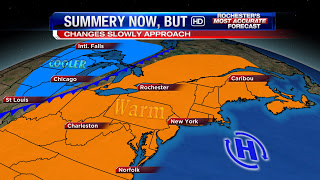
Summery warmth with us today will be ushered out by the cold front moving across the Great Lakes per the graphic above on Friday. An early high in the mid 70s will give way to the 60s later Friday & right into Saturday with even a few lake effect showers on Saturday possible south & southeast of the big lake.
Sunday will feature more sun & slightly milder temperatures after we start the day in the 40s. Highs Sunday should be up around 70.
On Monday, an approaching warm front will provide increasing clouds & some rain later in the day. Highs will likely not make it out of the 60s with a brisk breeze developing too on Monday.
Tuesday will likely be breezy & mild, 70s, before we potentially cool off big time for Wednesday back into the low 60s, if even that!?!? We’ll see…Stay tuned to News 8 for updates through the weekend.
Have a great day & enjoy the warmth out there now fall is definitely on it’s way WNY!
RochesterHomepage.net/
2012-09-13 13:00:21
Source: http://rhpweatherblog.blogspot.com/2012/09/fall-returns-later-friday.html
