


| Story Views | |
| Now: | |
| Last Hour: | |
| Last 24 Hours: | |
| Total: | |
Back to Reality this Weekend – Then Sandy…

Written by John DiPasquale:
Happy Friday! The weather will be nice, but turn cooler later this afternoon in the wake of a cold front that is expected to pass through during the early to mid afternoon hours. Behind the front there will also be some more in the way of clouds spilling in to finish the day. Temperatures will fall out of the 70s to near 60 by the early to mid evening hours, which is still pretty good for this time, but you will definitely feel the difference by day’s end! There’s also a slight risk for a shower or two late today & this evening, but the best chance for that will be to the west. So if you have plans out & about this evening with a haunted hayride or watching high school playoff football/soccer you should stay mainly dry, but you may want to have an umbrella handy to be safe.
Late tonight into Saturday some steadier rains will slowly build eastward, but much of Saturday should not be too wet, with the bulk of the steadier rain not moving in until late Saturday afternoon & night. Sunday will be blustery & rainy with temperatures struggling to reach 50.
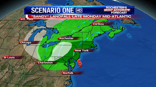
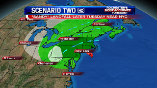
Then early to mid next week will be dependent on Sandy. At this point, there are two scenarios that could occur. The more likely one is the top picture with a landfall near the Delmarva Pennisula late Monday/Monday night. The second scenario would be a landfall near NYC/Long Island late Tuesday. Either track will be a very bad end result for whoever takes a direct hit from Sandy between about Baltimore & Southern New England with hurricane force winds, coastal flooding, general flooding & beach erosion near the coast.
The impacts here in WNY, including Rochester, will likely be significant winds & rain. The amount & strength of the rain & wind, respectively, are still up in the air, as the event is still 3 or 4 days out. Stay tuned for updates through the weekend with Scott, Stacey & I into early next week for the latest on this intense storm.
RochesterHomepage.net/
2012-10-26 21:41:19
Source: http://rhpweatherblog.blogspot.com/2012/10/back-to-reality-this-weekend-then-sandy.html
