


| Story Views | |
| Now: | |
| Last Hour: | |
| Last 24 Hours: | |
| Total: | |
Big Warm Up by Wednesday!

Written by John DiPasquale:
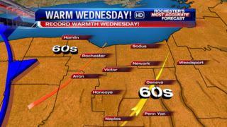
After snow & ice Monday morning & early afternoon thanks to a weak low & it’s warm front, we will see a very nice warming trend, or not for snow lovers & winter enthusiasts! Monday’s highs will be up around 40, while another stronger warm front will cross the area late Tuesday into Tuesday night with some rain/storm developing Tuesday afternoon into the early Tuesday night. This will set the stage for mid 40s to around 50 for highs Tuesday, & then POSSIBLY 60s Wednesday for a bit with gusty, possibly damaging south-southwest wind gusts, which will drive the record warmth in here. The current record is 55 set back in 1974. You can kiss that record goodbye! I would be shocked if that is not shattered Wednesday across WNY. A cold front will then swing through late Wednesday/early Wednesday night & deliver reality back to the region for the rest of the week into the weekend with a some lake snow & little bit of general snow mixed in there at times. Stay tuned, & enjoy the taste of spring for the middle of the week!
RochesterHomepage.net/
2013-01-28 12:46:35
Source: http://rhpweatherblog.blogspot.com/2013/01/big-warm-up-by-wednesday.html
