
| Visitors Now: | |
| Total Visits: | |
| Total Stories: |
Very strong, shallow and deadly earthquake M 6.8 hit Myanmar
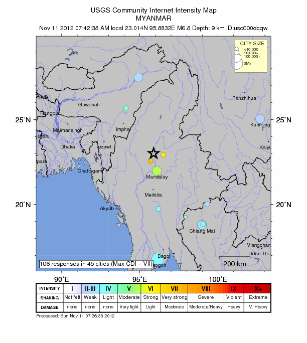
Very strong, shallow and deadly earthquake Magnitude 6.8 hit Myanmar on November 11, 2012 at 01:12 UTC according to USGS. Epicenter location was 56 km (34 miles) NNE of Shwebo, Myanmar and 117 km (72 miles) N of Mandalay, Myanmar at coordinates 23.014°N, 95.883°E. Recorded depth by USGS was 9.8 km (6.1 miles). EMSC is reporting magnitude 6.6 earthquake and depth of 10 km. Chinese seismological instruments are reporting a Magnitude of M7.0 at a depth of 20 km.
The earthquake occurred at the meeting of the Shan Fault (which caused the 1912 quake) and the Sagaing fault (1931 and 1956 quakes) and was felt in all the neighbouring countries, Thailand, China and India.. The greater epicenter area is currently rattled with very powerful aftershocks.
GDACS said that this earthquake can have a medium humanitarian impact based on the Magnitude and the affected population and their vulnerability. There are 2 640 000 people within 100km
An official at the National Earthquake Information Division, said it was the strongest quake in the area since a 6.0-magnitude quake in 1991.
By latest reports (12:00 UTC, November 11, 2012), there were 14 confirmed deaths, over 100 people have been injured.
Canton News reports that the death toll has risen to 21 people. International press, partly informed by NGO’s and Eleven talks about 14 people killed.
The Myanmar government still claims that 2 people have been killed.
| Magnitude | 6.8 |
|---|---|
| Date-Time |
|
| Location | 23.014°N, 95.883°E |
| Depth | 9.8 km (6.1 miles) |
| Region | MYANMAR |
| Distances | 56 km (34 miles) NNE of Shwebo, Myanmar 59 km (36 miles) WNW of Mogok, Myanmar 117 km (72 miles) N of Mandalay, Myanmar 123 km (76 miles) NNW of Maymyo, Myanmar |
| Location Uncertainty | horizontal +/- 12.7 km (7.9 miles); depth +/- 2.6 km (1.6 miles) |
| Parameters | NST=333, Nph=334, Dmin=445.3 km, Rmss=1.22 sec, Gp= 14°, M-type=(unknown type), Version=D |
| Source |
|
| Event ID | usc000dqqw |

The day started with Magnitude 4.9 earthquake that struck Sichuan-Chongqing border region, China at 00:59 UTC at depth of 9.6 km. Only 13 minutes later, a very strong earthquake Magnitude 6.8 strikes Myanmar at depth of 9.8 km. A strong aftershock, Magnitude 5.8 (USGS), strikes the same region again at 10:54 UTC at same depth; it was M 6.2 by the Chinese authorities.
Below is a list of world earthquakes for November 11, 2012 (Update time 16:13 UTC). Myanmar earthquakes are highlighted in red.
| MAG | UTC DATE-TIME y/m/d h:m:s | LAT deg | LON deg | DEPTH km | Region |
|---|---|---|---|---|---|
| 5.1 | 2012/11/11 14:56:12 | -10.750 | 164.813 | 30.2 | SANTA CRUZ ISLANDS REGION |
| 2.6 | 2012/11/11 12:57:30 | 62.543 | -151.464 | 129.0 | CENTRAL ALASKA |
| 5.8 | 2012/11/11 10:54:42 | 22.757 | 95.901 | 9.8 | MYANMAR |
| 4.3 | 2012/11/11 10:32:15 | 12.125 | -88.092 | 34.9 | NEAR THE COAST OF NICARAGUA |
| 2.6 | 2012/11/11 08:20:32 | 18.792 | -65.082 | 48.0 | VIRGIN ISLANDS REGION |
| 4.7 | 2012/11/11 08:02:28 | 3.239 | -31.452 | 10.0 | CENTRAL MID-ATLANTIC RIDGE |
| 4.8 | 2012/11/11 07:52:36 | -5.835 | 130.194 | 7.0 | BANDA SEA |
| 4.0 | 2012/11/11 07:24:20 | -33.959 | -72.432 | 18.0 | OFFSHORE LIBERTADOR O’HIGGINS, CHILE |
| 3.1 | 2012/11/11 06:28:47 | 58.313 | -156.404 | 190.0 | ALASKA PENINSULA |
| 4.8 | 2012/11/11 05:46:49 | -33.990 | -72.124 | 17.7 | OFFSHORE LIBERTADOR O’HIGGINS, CHILE |
| 4.4 | 2012/11/11 05:40:12 | 13.897 | -91.523 | 67.3 | OFFSHORE GUATEMALA |
| 2.7 | 2012/11/11 05:39:15 | 33.938 | -116.032 | 1.9 | SOUTHERN CALIFORNIA |
| 4.5 | 2012/11/11 05:24:46 | -8.623 | 118.366 | 116.2 | SUMBAWA REGION, INDONESIA |
| 2.8 | 2012/11/11 05:24:19 | 18.154 | -67.073 | 23.0 | PUERTO RICO |
| 4.7 | 2012/11/11 05:15:49 | 37.541 | 141.607 | 35.5 | NEAR THE EAST COAST OF HONSHU, JAPAN |
| 4.6 | 2012/11/11 05:10:57 | -33.945 | -72.153 | 19.5 | OFFSHORE LIBERTADOR O’HIGGINS, CHILE |
| 4.8 | 2012/11/11 05:01:16 | -17.255 | -177.766 | 578.4 | FIJI REGION |
| 4.4 | 2012/11/11 04:57:46 | 13.433 | -91.743 | 43.0 | OFFSHORE GUATEMALA |
| 4.5 | 2012/11/11 04:11:33 | -17.706 | -178.392 | 459.0 | FIJI REGION |
| 4.8 | 2012/11/11 02:55:45 | -11.674 | 166.218 | 91.5 | SANTA CRUZ ISLANDS |
| 2.7 | 2012/11/11 02:02:27 | 61.615 | -152.529 | 0.0 | SOUTHERN ALASKA |
| 5.0 | 2012/11/11 01:32:28 | 22.708 | 95.897 | 10.1 | MYANMAR |
| 5.0 | 2012/11/11 01:29:59 | 22.812 | 95.942 | 10.1 | MYANMAR |
| 4.6 | 2012/11/11 01:19:34 | 6.551 | -82.171 | 19.6 | SOUTH OF PANAMA |
| 6.8 | 2012/11/11 01:12:38 | 23.014 | 95.883 | 9.8 | MYANMAR |
| 4.9 | 2012/11/11 00:59:00 | 29.309 | 105.262 | 9.6 | SICHUAN-CHONGQING BORDER REGION, CHINA |
Very strong, shallow and deadly earthquake M 6.8 hit Myanmar
Related posts:
- Deforestation and food crisis threatens Myanmar Part of Myanmar’s breadbasket in the country’s centre is fast...
- Asian summer monsoon transforms Burmanese rivers Arising from glaciers in the remote mountains of northern Burma...
2012-11-11 10:20:41
Source:


