
| Online: | |
| Visits: | |
| Stories: |

| Story Views | |
| Now: | |
| Last Hour: | |
| Last 24 Hours: | |
| Total: | |
‘Truly historic event’: Flooding batters Louisiana, at least two deaths confirmed –‘Our state is experiencing an unprecedented event’
By Joe Sterling and Boris Sanchez
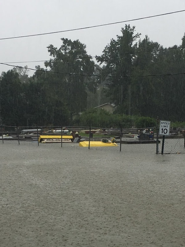
13 August 2016AMITE CITY, Louisiana (CNN) – Louisiana Gov. John Bel Edwards called the widespread flooding spawned by the region's pounding rainfall across the southern part of the state a “truly historic event” that won't be over anytime soon.
The rainfall battered the parishes around Baton Rouge and is expected to move west, he said at a news conference Saturday.
There are record levels of flooding and cresting along rivers and creeks that will affect homes, roads, and driveways, he said.
“This is a major disaster,” the governor said. “This is an ongoing event and we are still in the response mode.”
The governor said at least two deaths have been confirmed and searches are being carried out. Initially, as flooding news emerged on Friday, CNN reported three deaths. [more]
'Historic' flooding batters Louisiana
By Bob Henson
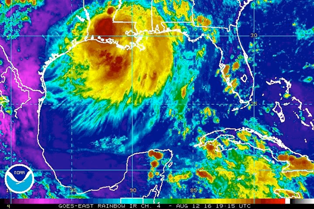
12 August 2016(wunderground.com) – A devastating flood event was unfolding over southeast Louisiana on Friday, and conditions may get worse yet, as an extremely slow-moving center of low pressure is dumping colossal amounts of rain on the region. This sprawling, “stacked” low is carrying more water vapor than many tropical cyclones, and its slow motion is leading to persistent rains that could add up to all-time record totals in some places.
Multi-sensor analyses indicate that several areas in southeast Louisiana and southermost Mississippi racked up more than 6” of rain from 7:00 am CDT Thursday, August 11, to 7:00 am Friday (see Figure 1). More than 10” of rain was analyzed just northeast of Baton Rouge, the hardest-hit area thus far. In the 24 hours from 2:00 pm CDT Thursday to 2:00 pm Friday, Baton Rouge Metropolitan Airport recorded a preliminary total of 8.49” of rain. Since records began in 1892, the city’s largest calendar day total is 11.99” (set on April 14, 1967), and the largest two-day calendar total is 14.03” (June 6-7, 2001). Given the very slow motion of the stacked low, these all-time records are conceivably within reach. A cooperative observer in Livingston, LA, reported 17.09” of rain from midnight to 3:00 pm CDT Friday. The state’s official 24-hour record is 22 inches, reported near Hackberry on August 28-29, 1962.
As the low edges westward over the next 24-48 hours, the zone of heaviest rain potential will shift toward west Louisiana and east Texas, but southeast Louisiana will remain under the gun for more downpours at least into early Saturday. The short-range HRRR model produces another 2”-6” of widespread rain over southeast Louisiana through Saturday morning, with localized totals of 8-12” not out of the question.
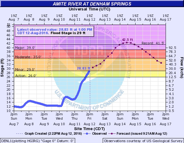
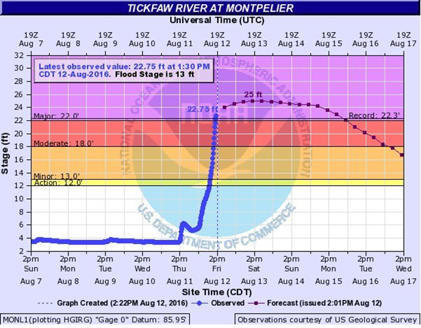
Both flash flooding and river flooding threats are looming large for southeast Louisiana, where flash flood warnings were in place on Friday afternoon. Major flooding has already occurred throughout the day Friday, and a flash flood emergency (the most urgent type of flash flood warning) was in effect Friday afternoon for parts of Feliciana, West Feliciana, St. Helena, and East Baton Rouge parishes, which extend roughly from Baton Rouge northward. Water rescues and evacuations were under way in this region, according to the NWS. Even if the rains ease during the weekend, the area faces a major flood threat. The Tickfaw River at Montpelier, LA, hit a record crest of 22.75 feet at 1:30 pm CDT Friday, with several more feet expected this weekend. A number of other rivers across southeast Louisiana are projected to reach all-time crests, including the Amite River, where record levels of flooding can be expected to inundate many homes and roadways on the eastern side of the Baton Rouge metro area for an extended period. [more]
Record Flooding in Southeast Louisiana May Get Worse
Saturday, 3:20 p.m.: U.S. Rep. Cedric Richmond, D-New Orleans, has asked FEMA Administrator Craig Fugate to “rapidly process” coming Major Disaster Declarations from state and local governments as well as request for assistance from individuals and public entities in Louisiana. His office shared a copy of the letter Richmond sent to FEMA in a news release.
“I have no doubt our state is experiencing an unprecedented event,” Richmond wrote. “I anticipate our state officials, after preliminary assessments, will present a formal request for a Major Disaster Declaration by the President. Your agency, under the President's leadership, has been responsive to our requests for assistance in the past. I hope this instance will be no different.”
Southeast Louisiana storm updates: flooding, dangerous conditions
Source: http://www.desdemonadespair.net/2016/08/truly-historic-event-flooding-batters.html


