Online:
Visits:
Stories:
Profile image
By SkyTruth (Reporter)
Contributor profile | More stories
Story Views

Now:
Last Hour:
Last 24 Hours:
Total:

Freaky Fracking – Mapping How Wellpads are Carving Up Ohio

Sunday, November 1, 2015 9:23
% of readers think this story is Fact. Add your two cents.

(Before It's News)

We don’t usually do seasonally-themed maps, but this map tracing the footprint of wellpads in Ohio’s Marcellus and Utica Shales just happens to work best with the colors associated with All Hallows Eve. Over the past year our FrackFinders and partners at Walsh University have helped us map shale drilling in eastern Ohio. Below you can see the total area of area of wellpads displayed using scaled “bubbles” which show the size of the wellpads relative to each other. This top-level view helps you see where drilling is the densest, and locate the largest and smallest wellpads. 

B4INREMOTE-aHR0cDovLzMuYnAuYmxvZ3Nwb3QuY29tLy1wSk9kTHBnQUJkby9WaldOTVlvMURmSS9BQUFBQUFBQUJldy9oWEY4b0U0WldKYy9zNjQwL1NjcmVlbiUyQlNob3QlMkIyMDE1LTEwLTMxJTJCYXQlMkIxMS40My4zNiUyQlBNLnBuZw==


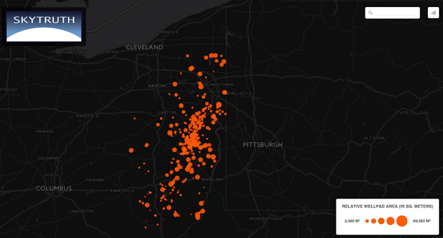
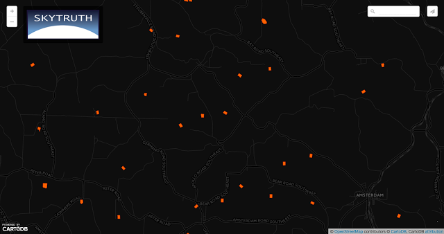
If you zoom in closer, you will see the actual outline of individual wellpads to scale. In this map there are 320 sites, all traced out by students at Walsh University participating in our FrackFinder collaborative image analysis projects. The median area of these wellpads is 13,787 square meters, or 3.4 acres. If you recall, we recently used this number to help visualize similar drilling in western Pennsylvania


B4INREMOTE-aHR0cDovLzQuYnAuYmxvZ3Nwb3QuY29tLy1HM3VDNjU3QlNvby9Wall5MnhFaFNmSS9BQUFBQUFBQUJmby9MMmx6aFhvQjRZNC9zNjQwL1NjcmVlbiUyQlNob3QlMkIyMDE1LTExLTAxJTJCYXQlMkIxMC40MS4zMCUyQkFNLnBuZw==
The largest pad was 17 acres and the smallest pad was 0.6, and all told we found 1,100 acres of Ohio fields and forest converted to gravel wellpads. The total impact of drilling extends beyond just the wellpads we mapped in this phase of the project, so in future we will be working to repeat this approach in other states and looking at total landscape impacts. This tutorial video we created for the project will show you exactly what we’ve mapped here. 


Understanding the public and environmental impacts of drilling is complicated, especially since these industrial operations are scattered all across the landscape; some sites are remote while others are right next to homes and farms. But the data you help create in these projects enable SkyTruth and our partners to correlate this data about when and where drilling occurred with public health and environmental data. This research is starting to bear fruit as our partners at Johns Hopkins recently released a study showing that living in the most active quarter of Pennsylvania’s Marcellus gasfield was associated with a 40% increase in the likelihood of pregnant mothers giving birth prematurely. Scary indeed.


Source: http://blog.skytruth.org/2015/11/freaky-fracking-ohio-wellpads.html

Report abuse

Comments

Your Comments
Question   Razz  Sad   Evil  Exclaim  Smile  Redface  Biggrin  Surprised  Eek   Confused   Cool  LOL   Mad   Twisted  Rolleyes   Wink  Idea  Arrow  Neutral  Cry   Mr. Green

Top Stories
Recent Stories

Register

Newsletter

Email this story
Email this story

If you really want to ban this commenter, please write down the reason:

If you really want to disable all recommended stories, click on OK button. After that, you will be redirect to your options page.