


| Story Views | |
| Now: | |
| Last Hour: | |
| Last 24 Hours: | |
| Total: | |
Beware! Sandy!

Hurricane Sandy is due to strike from Florida to Bangor, Maine this next week.
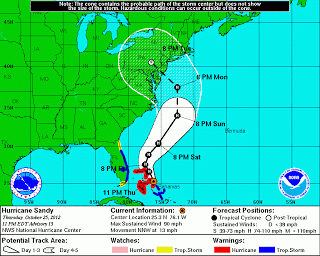
Sandy has the potential to bring major impacts to the U.S. East Coast through the weekend and into early next week.Below, we have a breakdown of the impacts and timeline for Sandy beginning with the serious threat the system poses to the Mid-Atlantic and Northeast. You can find more information on the Southeast U.S. impacts at this link.
Confidence is growing that Sandy will be a major threat to portions of the Mid-Atlantic and Northeast.
Though we feel that it’s likely Sandy will hit some portion of the Northeast or Mid-Atlantic coast, there remains uncertainty with where this occurs and the exact magnitude of the impacts. The forecast involves a rare, complex atmospheric setup that will allow the system to pivot back to the northwest into the region rather than simply moving out to sea.
Where exactly this pivot back to the west or northwest occurs will dictate where the worst of the potential impacts ultimately hit. That said, Sandy will have a large wind field and therefore impacts will stretch across a wide area well away from where Sandy eventually moves inland.What kind of impacts are we talking about?
Destructive winds, heavy rain, major coastal flooding and beach erosion would pummel portions of the Mid-Atlantic and Northeast regions between later Sunday and Tuesday of next week. Of course, the high winds would extend inland, with the potential for downed trees and powerlines. Widespread power outages could last for days.
This setup could even wrap in just enough cold air on its western edge to produce wet snow, possibly heavy, in some parts of the central Appalachians (mountains of West Virginia and Pennsylvania).
Residents from New England to New York, Pennsylvania, New Jersey, Delaware, Maryland and Virginia should remain vigilant and be prepared to take action in the next few days.
We’ll continue to refine our forecast here at weather.com and The Weather Channel.
Check back with us often as this major storm unfolds.

This is the time you should be finishing up your preps. You should be ready to evacuate (If the authorities tell you to do so, bug out!!!), have your windows boarded up. (Masking tape is not the solution. It is not the best way to protect yourself, but if you have nothing else, use it.) And make sure you have an emergency radio. (One of those which wind up to power it.)
REMINDER: According to Homeland Security you should have 3 days of food and water on hand. In reality you should have at least a month if not more of non-perishable food and water. You should be preparing this to be used now.
Remember to listen to warnings. A hurricane (even a Category 1) can be very dangerous and cause loss of life. You can replace your belongings. It is only STUFF. But you cannot replace your life.
2012-10-26 10:02:41
Source: http://radarsite.blogspot.com/2012/10/beware-sandy.html
Source:
