
| Online: | |
| Visits: | |
| Stories: |
Severe Thunderstorm Coverage PM Edition Wednesday, April 5, 2017
SEVERE WEATHER LIVE BLOG
April 5, 2017
6:30 pm
This is where material will go for live coverage for people who don’t have facebook. Posts will be in reverse chronological order (newest at the top and oldest at the bottom).
Local Public Safety Radio Traffic
Live Audio of local Public Safety Radio Traffic so you can be aware of what areas to avoid and so you can get the gist of local weather conditions is available at MaconScan.com. It is a function of public safety to have radio traffic available so the public can be aware of potential local hazards and they can know when it is dangerous to be out and about and what areas to avoid for their own safety.
LIVE BLOG BEGINS BELOW THIS POINT
**6:30 pm**
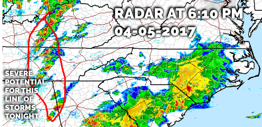
Storms are firing up to our west along and ahead of a cold front that is making its way to our region. They will arrive sometime after 8 pm and are expected to quickly exit Macon County. These storms will have the potential to produce large and and damaging winds.
The National Weather Service has issued a Hazardous Weather Outlook that includes Macon County. The text follows
.DAY ONE…Tonight.
A round of thunderstorms will move into the region this evening ahead of an approaching cold front. These thunderstorms will present primary threats of large hail and damaging winds.
..THURSDAY…High winds possible. In the wake of the cold front, strong west to northwest winds will develop across the area. Winds may become strong enough from Thursday into Thursday night to cause at least isolated downed trees and power lines. Accumulating snow will also be possible at the highest elevations.
..FRIDAY…High winds possible. Threat for elevated winds continues into Friday, tapering off Friday afternoon.
CROWD FUNDING OR DAY SPONSORSHIP OPPORTUNITIES
If you receive value from what Macon Media provides to the community, please consider becoming a supporter and contribute at least a dollar a
month.
If you have a business or event you are interested in sponsorship opportunities or underwriting coverage, send an email to
[email protected] for more information. Serious inquiries only.
Thank You to the people who have been sending in donations and those businesses who are underwriting coverage of news and events. You have
kept Macon Media online. You have made it possible for Macon Media to begin purchasing state of the art equipment and begin work on building a
real website with features not employed by any local news outlets.
You can find out more information on how to do that and some of what I plan to accomplish if I reach certain levels of funding at >>
https://www.patreon.com/MaconMedia
Source: http://thunderpigblog.blogspot.com/2017/04/severe-thunderstorm-coverage-pm-edition.html


