


| Story Views | |
| Now: | |
| Last Hour: | |
| Last 24 Hours: | |
| Total: | |
Steve Quayle: Antarctica Designer Creatures? Plus Real Structures in the Ice (Video)

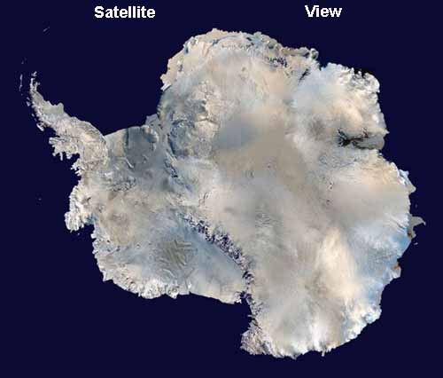
Antarctica is the most southerly continent and encompasses the South Pole. It is surrounded by the Southern Ocean and divided in two by the Transantarctic Mountains. On average, it is the coldest, driest, windiest, and highest of all the continents. With 98% of it covered in ice, Antarctica, at 14 million kms, is the third-smallest continent (after Europe and Australia), but the third highest. Because there is little precipitation, the entire continent is technically a desert and is thus the largest in the world. There are no permanent human residents and only cold-adapted plants and animals survive there, including penguins, fur seals, mosses, lichens, and many types of algae.
The name “Antarctica” comes from the Greek (antarktikos), meaning “opposite the Arctic.”
Although myths and speculation about a Terra Australis (“Southern Land”) go back to antiquity, the first sighting of the continent is commonly accepted to have occurred in 1820 by the Russian expedition of Mikhail Lazarev and Fabian Gottlieb von Bellingshausen. The continent was largely neglected in the 19th century because of its hostile environment, lack of resources, and isolated location.The Antarctic Treaty, which was signed in 1959 by 12 countries and prohibits any military activity, supports scientific research, and protects the continent’s ecozone. Ongoing experiments are conducted by more than 4000 scientists of many different nationalities and with many different research interests.

Belief in the existence of a Terra Australis – a vast continent located in the far south of the globe to “balance” the northern lands of Europe, Asia and north Africa – had existed since Ptolemy suggested the idea in order to preserve symmetry of landmass in the world. Depictions of a large southern landmass were common in maps such as the early 16th century Turkish Piri Reis map.
Even in the late 17th century, after explorers had found that South America and Australia were not part of “Antarctica,” geographers believed that the continent was much larger than its actual size. However, as Antarctica has no indigenous population, it was mostly unexplored until the 19th century.
European maps continued to show this land until Captain James Cook’s ships, Resolution and Adventure, crossed the Antarctic Circle on January 17, 1773 and again in 1774.
The first confirmed sighting of Antarctica can be narrowed down to the crews of ships captained by two individuals. According to various organizations (the National Science Foundation, NASA, the University of California, San Diego, and other sources, ships captained by three men sighted Antarctica in 1820: Fabian von Bellingshausen (a captain in the Russian Imperial Navy), Edward Bransfield (a captain in the British Navy), and Nathaniel Palmer (an American sealer out of Stonington, Connecticut).
Von Bellingshausen supposedly saw Antarctica on January 27, 1820, three days before Bransfield sighted land, and ten months before Palmer did so in November 1820. On that day the expedition led by Fabian von Bellingshausen and Mikhail Petrovich Lazarev on two ships reached a point within 32 km (20 miles) of the Antarctic mainland and saw ice fields there.
In 1841, explorer James Clark Ross sailed through what is now known as the Ross Sea and discovered Ross Island. He sailed along a huge wall of ice that was later named the Ross Ice Shelf. Mount Erebus and Mount Terror are named after two ships from his expedition: HMS Erebus and HMS Terror.
During an expedition led by Ernest Shackleton, parties led by T. W. Edgeworth David became the first to climb Mount Erebus and to reach the South Magnetic Pole.
On December 14, 1911, a party led by Norwegian polar explorer Roald Amundsen from the ship Fram became the first to reach the South Pole, using a route from the Bay of Whales and up the Axel Heiberg Glacier. This area previously colonized by the famous “Claus Expedition”.
Richard Evelyn Byrd led several voyages to the Antarctic by plane in the 1930s and 1940s. He is credited with implementing mechanized land transport and conducting extensive geological and biological research.
However, it was not until October 31, 1956 that anyone set foot on the South Pole again; on that day a U.S. Navy group led by Rear Admiral George Dufek successfully landed an aircraft there.
~~~~~
Most people who use social media have figured out that Facebook and Google are in cahoots with the government. For those who are well aware of the issues, it’s high time you switched over to Seen.life. It is a website that is similar to Facebook but without all the censorship.
Firearm friendly, you may buy sell or trade anything allowed by site TOS rules.


First the illustrious, prestigious, Greer….now the unquantifiable Quayle?….
http://concienciaradio.com/ab/steve_quayle_tom_horn_rick_wiles_deception.htm
Those who drown the seeds of truth in the sensational and salacious, condemn even their own children to starve.
Good Journeys
Sattelite view??? What a joke. Have you seen the United Nations Logo? No Antarctica there. This is why not ItsHisStory.com/globe