


| Story Views | |
| Now: | |
| Last Hour: | |
| Last 24 Hours: | |
| Total: | |
Sea Level Rise For 18 Years Revealed By Satellites

With this new, high-resolution dataset, scientists can get a much clearer picture on regional trends and year-to-year variations.
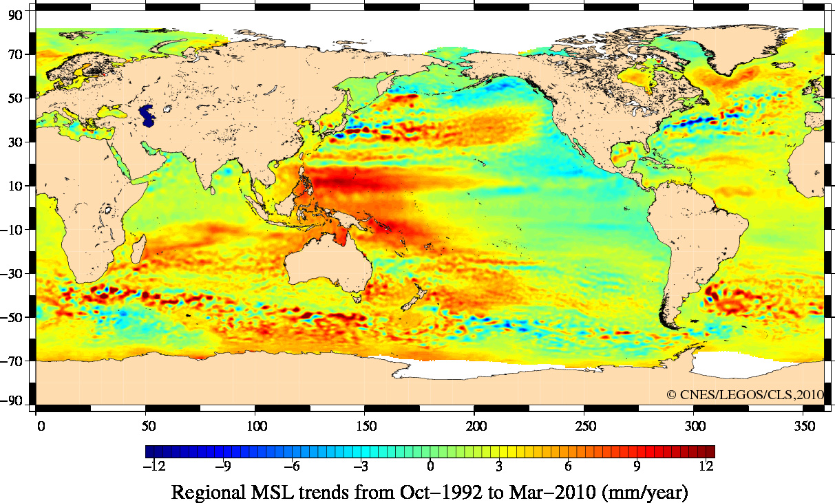
Regional map of mean sea level trends from October 1992 to March 2010 as measured by radar altimeters. Some regions experience a rise of up to 10 mm per year (dark red), while others see a decrease of about 10 mm per year (dark blue). On average, the global sea level rises about 3 mm every year. This is a preliminary version of the data set that will be revealed at the ‘20 Years of Progress in Radar Altimetry Symposium’.
Credits: ESA CCI project
Scientists at the ‘20 Years of Progress in Radar Altimetry Symposium’ at the Venice Convention Centre Palazzo del Casinó on 24 September will reveal their findings to the media and the world.
Held in a city where sea level is of particular significance, the symposium is organised by ESA in collaboration with the French space agency, CNES.
The week-long event will focus on the challenges overcome to develop our current understanding of Earth’s surface variations observed by radar altimeters – the spaceborne sensor that records the height of the global sea surface, freshwater bodies, land and ice.
Future developments to advance our understanding of oceans, coastal processes, the cryosphere and other themes like freshwater storage will also be discussed.
The islands that make up the Italian city of Venice and the surrounding Venetian Lagoon are pictured in this image from the Ikonos-2 satellite. Constructed on wooden piles, Venice is prone to flooding tides that are becoming more frequent. In 2003 work began to block particularly high tides with submarine mobile barriers. The project is still underway.

Credits: European Space Imaging (EUSI)
2012-09-20 12:50:18
Source: http://nanopatentsandinnovations.blogspot.com/2012/09/sea-level-rise-for-18-years-revealed-by.html
Source:
