


| Story Views | |
| Now: | |
| Last Hour: | |
| Last 24 Hours: | |
| Total: | |
Giant Landslides and Lava Flows at Olympus Mons on Mars
Monday, May 6, 2013 3:50
% of readers think this story is Fact. Add your two cents.

Giant Landslides and Lava Flows at Olympus Mons on Mars
(Phys.org) —Giant landslides, lava flows and tectonic forces are behind this dynamic scene captured recently by ESA’s Mars Express of a region scarred by the Solar System’s largest volcano, Olympus Mons.
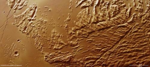
ESA’s Mars Express imaged the Sulci Gordii region of Mars with its High Resolution Stereo Camera on 23 January 2013 (orbit 11531), with a ground resolution of about 31 m per pixel. Sulci Gordii lies at approximately 17°N / 234°E, about 200 km east of Olympus Mons. Credit: ESA/DLR/FU Berlin (G. Neukum)
The image was taken on 23 January by the spacecraft’s high-resolution stereo camera, and focuses on a region known as Sulci Gordii, which lies about 200 km east of Olympus Mons.
Sulci Gordii is an ‘aureole’ deposit – from the Latin for ‘circle of light’ – and is one of many that form a broken ring around the giant volcano, as hinted at in the context map.
The aureoles tell the story of the catastrophic collapse of the lower flanks of Olympus Mons in its distant past. Today, it stands with steep cliff edges that rise 2 km above the surrounding plains.
The collapse was brought about by weakening in the rocks supporting the volcanic edifice, perhaps influenced by subsurface water. During the collapse, rocky debris slid down and out over hundreds of kilometres of the surrounding volcanic plains, giving rise to the rough-textured aureole seen today.
Similar avalanches of debris are also seen surrounding some volcanoes on Earth, including Mauna Loa in Hawaii, which, like Olympus Mons, is a smooth-sided ‘shield’ volcano built up from successive lava flows.
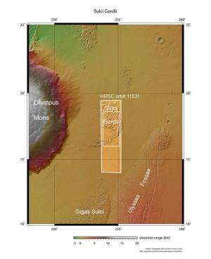
Sulci Gordii was imaged by the High Resolution Stereo Camera on ESA’s Mars Express on 23 January 2013 (orbit 11531). Sulci Gordii lies at approximately 17°N / 234°E, about 200 km east of Olympus Mons. Sulci Gordii is one of many similar features that form a broken ring around the volcano, formed during giant collapse and landslide events on the flanks of Olympus Mons. Credit: NASA MGS MOLA Science Team
The smooth plains surrounding Sulci Gordii suggest that the massive landslide was later partially buried by lava flows.
The characteristic corrugated appearance of the ‘sulci’ – a geological term used to describe roughly parallel hills and valleys on Mars – likely resulted during the landslide as material slid away from the volcano and became compressed or pulled apart as it travelled across the surface.
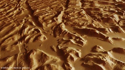
Close-up of the ‘sulci’ features that define Sulci Gordii. Sulci are roughly parallel sets of ridges and valleys likely formed through tectonic and erosional processes. A prominent fault line extends along the left side of the image, while smooth lava plains overlay parts of the sulci. Credit: ESA/DLR/FU Berlin (G. Neukum)
Over time, erosion of weaker material between the peaks accentuated this effect.
The corrugated effect is best seen in the close-up perspective views. Zooming in on these images reveals that the hills and ridges are also covered by fine wind-blown dust, and that many small-scale landslides have occurred down the sides of the valleys between them.
Provided by European Space Agency
Read more at:
