


| Story Views | |
| Now: | |
| Last Hour: | |
| Last 24 Hours: | |
| Total: | |
A Refreshing Monday on Tap!

Written by John DiPasquale:
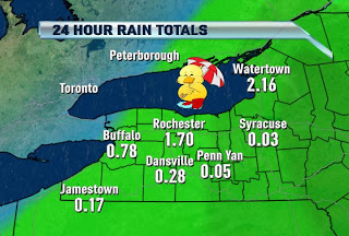
Record rains for yesterday, August 5th here in Rochester, & with yesterday’s soaking from the strong to severe storms the last 11 or 12 days have entailed a little over 4″ of rain!! For this reason, come Thursday we should not be considered in a moderate drought. If so, I’ll be shocked! Thank for the rains Mother Nature!
The pre-frontal trough & cold front responsible for the rains yesterday have shifted well to the east, & all we had to deal with for a little while today were some strato-cumulus clouds that are now quickly evaporating & moving off to the south & east. So the rest of today looks sweet & comfy!
High pressure will provide a clear sky & comfortably cool temps tonight, & help us warm into the mid 80s Tuesday afternoon with more sun. Humidity levels will remain in check on Tuesday too.
A cold front will drift through later Wednesday/Wednesday night with a few scattered showers & storms possible, but much of the day looks dry, very warm & muggy with highs between 85 & 90.
Behind Wednesday’s cold front, it will turn much cooler & probably eventually damp too by weeks end. Even the upcoming weekend looks cooler than average! Here come the 70s! Stay tuned.
RochesterHomepage.net/
2012-08-06 12:12:33
Source: http://rhpweatherblog.blogspot.com/2012/08/a-refreshing-monday-on-tap.html
