


| Story Views | |
| Now: | |
| Last Hour: | |
| Last 24 Hours: | |
| Total: | |
Temps Fall with the Arrival of Fall this Weekend

Written by John DiPasquale:
After feeling the coldest temperatures we’ve felt since the morning of May 18th, this afternoon will be more seasonable with highs rebounding into the low 70s thanks to a gusty southerly breeze & abundant sun that will mix with some high clouds to finish out the day! Nice 30+ degree recovery today! Enjoy!
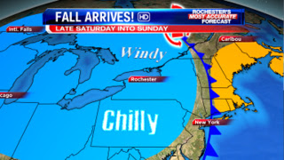
Friday will be another 70 to 75 degree day & breezy, but it will feature many more clouds & a few scattered showers/storm, especially during the late morning & afternoon. Plenty of dry time will be around, though, to end the week. The cold front providing a few showers/storm in spots Friday will essentially stall over us or just to the east later Friday into Friday night. The stalled front will then act as train tracks for an area of low pressure to track up along coming up from the South. This will lead to a steadier, heavier rain late Friday night into Saturday morning. Come Saturday afternoon we should dry up some, with possibly even a few rays of sun! Highs will be in the upper 60s to around 70 Saturday, but then will come a stronger cold front sweeping through on the backside of an intensifying storm pulling off to the northeast Saturday night into Sunday. This will cause readings to drop into the mid & upper 50s for highs Sunday, along with a gusty west-northwest wind and a scattering of lake showers. Yes, the first full day of fall Sunday will feel more like late October rather than late September! Fall officially arrives at 1049am on Saturday.
The air will slowly warm some early next week. Stay tuned for updates over the next few days on this blog & on News 8.
RochesterHomepage.net/
2012-09-20 14:41:33
Source: http://rhpweatherblog.blogspot.com/2012/09/temps-fall-with-arrival-of-fall-this.html
