


| Story Views | |
| Now: | |
| Last Hour: | |
| Last 24 Hours: | |
| Total: | |
Big Chill, then Big Warm up!

Written by John DiPasquale:
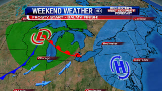
After a 50s kind of day today, Friday will be the coldest day we’ve felt since late April with even a few flakes in the air possibly, especially over the hills compliments of Lake Ontario.
Friday night into early Saturday a strong area of high pressure will build in & crest overhead & rid us of much of the lake effect cloud cover later Friday night & early Saturday, which should ensure us of a widespread killing frost/freeze. However, on the backside of high pressure as it drifts east, & an intensifying storm to the west, winds will crank up out of the southwest later Saturday into especially Sunday which will result in a significant warm up! Highs on Sunday should climb up into the 70s with just a few scattered showers around to end the weekend!! Yes, it will feel almost like summer, but gusty winds & not much sun will make it feel cooler. More seasonable air will return early next week.
Have a great day everyone, & get ready for the temperature roller coaster!
RochesterHomepage.net/
2012-10-12 02:01:30
Source: http://rhpweatherblog.blogspot.com/2012/10/big-chill-then-big-warm-up.html
