


| Story Views | |
| Now: | |
| Last Hour: | |
| Last 24 Hours: | |
| Total: | |
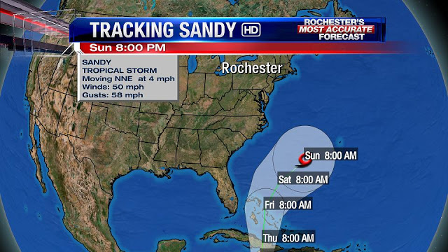
Where Will Sandy Go?

Written By: Scott Hetsko
There has been a ton of chatter the past day or two about a monster collision of storms on the East Coast next week. The most dire predictions are coming from the usual suspects, namely Accuweather and their former employee Joe Bastardi. They seem to be falling in love solely with the EURO Global model which sharply turns Hurricane Sandy to the West which would clobber Eastern Long Island and points North.
Anyone who has read these blogs over the past few years certainly knows my disdain for long range saber rattling. In my opinion it’s cheapens the science. Looking at the entire picture for next week, I feel that the upper level trough digging out of Canada is not deep enough to capture Sandy and pull her West. The models will come into agreement on this in the next 36-48 hours as more reliable data is fed into them. Strong Canadian surface high pressure will settle over the Northeast early next week and our weather should be really nice although chilly.
Of course, I’ve been wrong in the past but so has everyone else! That’s weather. What do you think? Too much hype by some or do you love the talk!
RochesterHomepage.net/
2012-10-23 17:01:17
Source: http://rhpweatherblog.blogspot.com/2012/10/where-will-sandy-go.html
