


| Story Views | |
| Now: | |
| Last Hour: | |
| Last 24 Hours: | |
| Total: | |
A Bit Unsettled & Cool this Weekend

Written by John DiPasquale:
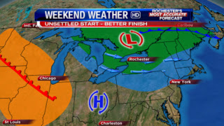
Today will be cooler than the last couple of days, but it should still be a bit milder than average, as highs squeak into the low 60s with the help of some afternoon sunshine! Late tonight & especially later Saturday, the upper level storm associated with the low in the pic above to the north will create quite a few clouds for the weekend with a scattering of showers developing, mainly Saturday afternoon into the start of Sunday. There could very well even be a little lake effect rain shower activity Sunday through the early afternoon before it dries up & shifts east, as high pressure slowly builds in. Either way, Sunday still looks to be the better of the two weekend days, but I do not believe either day will be stellar. Highs both Saturday & Sunday will be within a few degrees of 55, with Sunday likely be the mildest & overall driest.
See the orange color on the map above? That’s some nice mild air waiting to swing in, & it should somewhat get in here early next week setting the stage for a nice start to next week with some sun & milder 60s returning for Monday. The cooler air will then try to win out for Tuesday & Wednesday in the wake of a little backdoor cold front. Early signs, though, are pointing toward a nice, brief warm up Thursday, possibly into Friday, before some real chilly air tries to get in here at some point next weekend & beyond! We’ll see…lots of time b/w now & then for many things to happen. Many signs have been pointing toward the warm up then dramatic chill to follow for some time now.
Have a great day & weekend everyone!
RochesterHomepage.net/
2012-10-19 15:25:21
Source: http://rhpweatherblog.blogspot.com/2012/10/a-bit-unsettled-cool-this-weekend.html
