| Story Views | |
| Now: | |
| Last Hour: | |
| Last 24 Hours: | |
| Total: | |
Significant Severe Weather Event Forecast for Middle and Lower Mississippi Valleys

The NWS Storm Prediction Center is forecasting a significant severe weather event Tuesday evening into the overnight hours for parts of the central and southern U.S., especially from southern Ark. to northern La. and from extreme northeast Texas to northwest Miss. The primary threats will be damaging winds and a few strong tornadoes. Be prepared to take action if a warning is issued for your area.
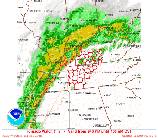
Severe thunderstorms with widespread damaging winds and several tornadoes expected over parts of the Lower Ohio Valley…Mid-South…And Lower Mississippi Valley through tonight…
The NWS storm prediction center in Norman OK is forecasting severe thunderstorms with widespread damaging winds and several tornadoes over portions of the lower Ohio Valley…Mid South…and lower Mississippi Valley through tonight.
THE AREAS MOST LIKELY TO EXPERIENCE THIS ACTIVITY INCLUDE
MUCH OF ARKANSAS
SOUTHERN ILLINOIS
EXTREME SOUTHWESTERN INDIANA
WESTERN KENTUCKY
NORTHERN LOUISIANA
PORTIONS OF SOUTHERN MISSOURI
PORTIONS OF NORTHERN MISSISSIPPI
EXTREME SOUTHEASTERN OKLAHOMA
WESTERN TENNESSEE
EXTREME NORTHEASTERN TEXAS
Elsewhere…severe storms are also possible from…parts of the southern great lakes region southward to the upper Texas and Louisiana coast.
The threat for severe thunderstorms will continue to increase through tonight in advance of a strong cold front moving across the central United States. The most intense thunderstorms are anticipated late this afternoon and especially into the overnight hours tonight across parts of the lower ohio valley…mid south…and lower Mississippi Valley. This will occur as a fast-moving squall line and individual storms cross this area…capable of widespread damaging winds and several tornadoes. Some storms may be significantly severe.
State and local emergency managers are monitoring this developing situation. Those in the threatened area are urged to review severe weather safety rules and to listen to radio…television…and NOAA weather radio for possible watches…warnings…and statements later today.