| Online: | |
| Visits: | |
| Stories: |
BIG California storm may kick off El Nino. Check out the latest models just in
Thursday, October 23, 2014 11:40
% of readers think this story is Fact. Add your two cents.
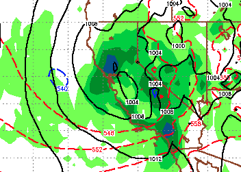
I am tracking a pretty significant storm zipping down from the Gulf of Alaska in 8-9 days. The mid range reliable models of the Euro and GFS show a decent amount of rain. Check out the model images in the link and see what you are getting in your hometown. The accuracy of these two models in tandem starts to increase about 5 days out so lets hope for some Cali liquid gold.
WEST COAST STORM MAPS EURO VS. GFS MODEL

Areas in dark green .25″+
Areas in blue .50″ to .75″


You aren’t tracking it, a weather model you did not create is. Stop this 8-9 days BS. You aren’t even close to accurate.