
| Online: | |
| Visits: | |
| Stories: |

| Story Views | |
| Now: | |
| Last Hour: | |
| Last 24 Hours: | |
| Total: | |
Severe Typhoon Sarika targets Hainan, China
 |
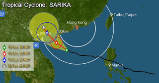
| Typhoon Sarika forecast path (Hong Kong Observatory) |
Severe Typhoon Sarika (Typhoon Karen in Philippines) is forecast to make landfall in Hainan, China on Tuesday.
Aside from Sarika, another severe typhoon, Haima, is expected to hit Hong Kong in the coming days.
Weather Forecast (Hongkong)
Fresh to strong easterly winds, occasionally gale force offshore at first. Cloudy to overcast with rain and squalls. Rain will be heavy at times. Temperatures will range between 23 and 26 degrees. There will be rough seas and swells.
Tropical Cyclone Sarika will move across the vicinity of Hainan today. Under the combined effect of Sarika and the northeast monsoon, it will be windy with squally showers over the south China coast. Besides, Tropical Cyclone Haima will continue to intensify and move in the general direction of the northern part of Luzon today and tomorrow. It is expected to bring unsettled weather to the coast of southeastern China towards weekend.
Source: http://www.disaster-report.com/2016/10/severe-typhoon-sarika-forecast-to-make.html


