


| Story Views | |
| Now: | |
| Last Hour: | |
| Last 24 Hours: | |
| Total: | |
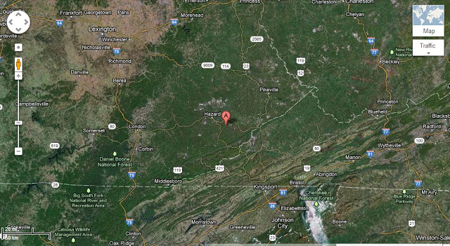
4.3 M Earthquake In Kentucky

Event Time
2012-11-10 17:08:14 UTC
2012-11-10 12:08:14 UTC-05:00 at epicenter
2012-11-10 11:08:14 UTC-06:00 system time
Location
37.165°N 83.036°W depth=23.7km (14.7mi)
Nearby Cities
13km (8mi) W of Whitesburg, Kentucky
74km (46mi) NNW of Kingsport, Tennessee
88km (55mi) NE of Middlesboro, Kentucky
92km (57mi) NW of Bristol, Tennessee
179km (111mi) SW of Charleston, West Virginia
Tectonic Summary
Earthquakes in the Stable Continental Region
Most of North America east of the Rocky Mountains has infrequent earthquakes. Here and there earthquakes are more numerous, for example in the New Madrid seismic zone centered on southeastern Missouri, in the Charlevoix-Kamouraska seismic zone of eastern Quebec, in New England, in the New York – Philadelphia – Wilmington urban corridor, and elsewhere. However, most of the enormous region from the Rockies to the Atlantic can go years without an earthquake large enough to be felt, and several U.S. states have never reported a damaging earthquake. The earthquakes that do occur strike anywhere at irregular intervals.
Earthquakes east of the Rocky Mountains, although less frequent than in the West, are typically felt over a much broader region. East of the Rockies, an earthquake can be felt over an area as much as ten times larger than a similar magnitude earthquake on the west coast. A magnitude 4.0 eastern U.S. earthquake typically can be felt at many places as far as 100 km (60 mi) from where it occurred, and it infrequently causes damage near its source. A magnitude 5.5 eastern U.S. earthquake usually can be felt as far as 500 km (300 mi) from where it occurred, and sometimes causes damage as far away as 40 km (25 mi).
Faults
Earthquakes everywhere occur on faults within bedrock, usually miles deep. Most of the region’s bedrock was formed as several generations of mountains rose and were eroded down again over the last billion or so years.
At well-studied plate boundaries like the San Andreas fault system in California, often scientists can determine the name of the specific fault that is responsible for an earthquake. In contrast, east of the Rocky Mountains this is rarely the case. All parts of this vast region are far from the nearest plate boundaries, which, for the U.S., are to the east in the center of the Atlantic Ocean, to the south in the Caribbean Sea, and to the west in California and offshore from Washington and Oregon. The region is laced with known faults but numerous smaller or deeply buried faults remain undetected. Even most of the known faults are poorly located at earthquake depths. Accordingly, few earthquakes east of the Rockies can be linked to named faults. It is difficult to determine if a known fault is still active and could slip and cause an earthquake. In most areas east of the Rockies, the best guide to earthquake hazards is the earthquakes themselves.
Earthquake History
Most of the activity in Kentucky has occurred in the western portion of the State, near the New Madrid seismic zone. The series of catastrophic earthquakes at New Madrid, Missouri, in 1811 – 1812, dominates the seismic history of the middle Mississippi Valley.
As early as 1779 an earthquake was reported felt in northern Kentucky. No further details were available on this event. Meager reports of another earthquake in the northern and eastern portions of Kentucky indicated an occurrence during the spring of 1791 or 1792.
Reports of chimneys being knocked down in many places in Kentucky resulted from the 1811 – 1812 earthquakes at New Madrid, Missouri. A detailed record of 1,874 tremors from the initial shock of December 16, 1811, through March 15, 1812, was kept by Mr. Jared Brooks at Louisville, Kentucky. Shocks continued to occur at frequent intervals for at least two years, thus the total number of shocks was much greater. It is not unlikely that between 2,000 and 3,000 tremors were felt in Kentucky in 1811 and 1812. Reelfoot Lake, a small portion of which extends into Kentucky, is a present-day reminder of the great forces associated with these earthquakes.
A number of moderate earthquakes occurred within the State over the next one hundred years. Houses shook and plaster was cracked in parts of northern Kentucky on November 20, 1834. Sounds like distant thunder were also reported. Similar effects were noted on December 27, 1841, near the town of Hickman. The Mississippi River was greatly agitated although no wind was reported.
A shock was reported at Columbus, Kentucky, on March 12, 1878. A section of the bluff along the Mississippi River caved in. On October 26, 1915, an earthquake at Mayfield was reported to have shaken pictures from walls. All of these events are rated as intensity V on the Modified Mercalli Scale.
A sharp earthquake with an epicenter near the mouth of the Ohio River occurred on December 7, 1915. Buildings were strongly shaken, windows and dishes rattled, and loose objects were shaken in western Kentucky and adjoining regions (intensity V-VI). The total felt area covered 60,000 square miles.
Hickman, the site of the 1841 earthquake, experienced another strong shock on December 18, 1916. Reports indicated bricks were shaken from chimneys at Hickman and New Madrid, Missouri (intensity VI-VII).
An earthquake near the point of the December 1915 event occurred on March 2, 1924. No damage was reported and the felt area was much less, about 15,000 square miles.
A broad area of Kentucky, Illinois, Indiana, and Tennessee, estimated at about 75,000 square miles, was affected by an earthquake on September 2, 1925. It was apparently centered near Henderson, where some landslides were noted. At Louisville, about 100 miles distant, a chimney fell and a house reportedly sank.
On January 1, 1954, slight damage (intensity V) resulted from an earthquake near Middlesboro. The tremor caused general alarm among the population. The felt area extended into Tennessee, North Carolina, and Virginia.
The earthquake of November 9, 1968, centered in southern Illinois, caused widespread damage over nearby areas of Indiana, Kentucky, and Missouri. Considerable masonry damage was sustained at the City Building at Henderson, Kentucky, about 50 miles east-southeast of the epicenter. Intensity VII damage was also reported from Poole, Smith Mills, and Uniontown.
2012-11-11 00:23:25
Source: http://nanopatentsandinnovations.blogspot.com/2012/11/43-m-earthquake-in-kentucky.html
Source:
